Home > Maps and Charts > British Empire Maps
Jigsaw Puzzle : British Empire Map 1880


![]()
Jigsaw Puzzles from Mary Evans Picture Library
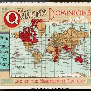
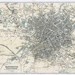
British Empire Map 1880
Map showing the extent of the British Empire circa 1880
Mary Evans Picture Library makes available wonderful images created for people to enjoy over the centuries
Media ID 608738
© Mary Evans Picture Library 2015 - https://copyrighthub.org/s0/hub1/creation/maryevans/MaryEvansPictureID/10113710
Jigsaw Puzzle (252 Pieces)
Discover the rich history of the British Empire with the Media Storehouse Jigsaw Puzzles' "British Empire Map 1880" from Mary Evans Picture Library. This captivating puzzle features an intricately detailed map depicting the extent of the British Empire at its peak around 1880. Bring history to life in your own home as you piece together this jigsaw puzzle. The high-quality image from Mary Evans Prints Online ensures a stunning and accurate representation of this significant historical moment. Engage in a challenging and rewarding experience as you explore the intricacies of this puzzle, perfect for history enthusiasts or anyone seeking a brain-teasing activity. Immerse yourself in the past and create a beautiful display piece once completed.
Made in the USA, 252-piece puzzles measure 11" x 14" (27.9 x 35.5 cm). Every puzzle is meticulously printed on glossy photo paper, which has a strong 1.33 mm thickness. Delivered in a black storage cardboard box, these puzzles are both stylish and practical. (Note: puzzles contain small parts and are not suitable for children under 3 years of age.)
Jigsaw Puzzles are an ideal gift for any occasion
Estimated Product Size is 35.6cm x 28cm (14" x 11")
These are individually made so all sizes are approximate
Artwork printed orientated as per the preview above, with landscape (horizontal) orientation to match the source image.
FEATURES IN THESE COLLECTIONS
> Maps and Charts
> British Empire Maps
> Maps and Charts
> Early Maps
> Maps and Charts
> World
EDITORS COMMENTS
This stunning print showcases a detailed map of the British Empire in 1880, capturing the vast extent of British colonial power during this pivotal period in history. The intricate details and vibrant colors bring to life the various territories and regions under British rule, from India to Africa to Australia and beyond.
The red shading on the map highlights the sheer magnitude of influence that Britain held over a significant portion of the world at that time. It serves as a visual representation of imperial dominance and control, reflecting an era when Britannia truly ruled the waves.
As we gaze upon this historical artifact, we are transported back to a time when empires were built through conquest and colonization. The legacy of the British Empire is complex and multifaceted, with both positive contributions and negative consequences felt across the globe.
This map is not just a geographical representation but also a symbol of power, ambition, and imperialism. It reminds us of an era when borders were redrawn by force, cultures clashed, and millions of lives were forever changed by colonial expansion.
Through this print from Mary Evans Picture Library, we are given a glimpse into a world shaped by empire-building ambitions – a world where Britannia's reach truly knew no bounds.
MADE IN THE USA
Safe Shipping with 30 Day Money Back Guarantee
FREE PERSONALISATION*
We are proud to offer a range of customisation features including Personalised Captions, Color Filters and Picture Zoom Tools
SECURE PAYMENTS
We happily accept a wide range of payment options so you can pay for the things you need in the way that is most convenient for you
* Options may vary by product and licensing agreement. Zoomed Pictures can be adjusted in the Cart.


![Glasgow Central Station. Caledonian Railway [N. D]](/sq/229/glasgow-central-station-caledonian-railway-n-13155169.jpg.webp)