Home > Arts > Artists > B > Martin Behaim
Photographic Print : World Map / Behaim 1492


![]()
Photo Prints from Mary Evans Picture Library
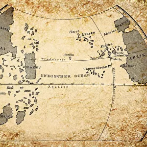
World Map / Behaim 1492
Map of the world in two halves, according to Martin Behaim
Mary Evans Picture Library makes available wonderful images created for people to enjoy over the centuries
Media ID 608729
© Mary Evans Picture Library 2015 - https://copyrighthub.org/s0/hub1/creation/maryevans/MaryEvansPictureID/10113673
1492 Halves Maps Martin Behaim
14"x11" Photo Print
Introducing the captivating collection of Photographic Prints from Media Storehouse, featuring the iconic "World Map / Behaim 1492" image from Mary Evans Prints Online. This exquisite map, dating back to 1492, is an intriguing testament to the rich history of cartography. Divided into two halves, this captivating representation of the world, as it was once known, offers a glimpse into the past, showcasing the discoveries and explorations that shaped our understanding of the globe. Add an air of mystery and historical charm to your space with this stunning, high-quality photographic print.
Photo prints are produced on Kodak professional photo paper resulting in timeless and breath-taking prints which are also ideal for framing. The colors produced are rich and vivid, with accurate blacks and pristine whites, resulting in prints that are truly timeless and magnificent. Whether you're looking to display your prints in your home, office, or gallery, our range of photographic prints are sure to impress. Dimensions refers to the size of the paper in inches.
Our Photo Prints are in a large range of sizes and are printed on Archival Quality Paper for excellent colour reproduction and longevity. They are ideal for framing (our Framed Prints use these) at a reasonable cost. Alternatives include cheaper Poster Prints and higher quality Fine Art Paper, the choice of which is largely dependant on your budget.
Estimated Image Size (if not cropped) is 35.5cm x 20.6cm (14" x 8.1")
Estimated Product Size is 35.5cm x 27.9cm (14" x 11")
These are individually made so all sizes are approximate
Artwork printed orientated as per the preview above, with landscape (horizontal) orientation to match the source image.
FEATURES IN THESE COLLECTIONS
> Arts
> Artists
> B
> Martin Behaim
> Maps and Charts
> Early Maps
EDITORS COMMENTS
This stunning World Map, created in 1492 by the Nuremberg cartographer Martin Behaim, is a testament to the fascinating and complex history of cartography during the Age of Discovery. The map is unique in its representation of the world as divided into two distinct halves, with the eastern and western hemispheres separated by the Indian Ocean. Behaim, who is believed to have traveled extensively, incorporated the latest geographical knowledge available at the time, including the recent discovery of the New World by Christopher Columbus. The map's intricate details and vibrant colors bring to life the known world of the late 15th century, with Europe, Africa, and Asia depicted in their entirety, and the Americas, still largely unexplored, represented only by a rough outline. The map also features numerous annotations and illustrations, including depictions of various cities, islands, and mythical places. Despite its age, the Behaim World Map remains an important historical artifact, providing valuable insights into the geographical knowledge and beliefs of the time. Its intricate design and rich details continue to captivate scholars, historians, and cartography enthusiasts alike, making it a must-see for anyone interested in the history of exploration and the development of global awareness. This print, from the Mary Evans collection, offers a rare opportunity to own a piece of cartographic history, allowing us to explore the world as it was understood over 500 years ago. Whether displayed as a conversation piece in a home or office, or used as a teaching tool in an educational setting, this print is sure to inspire wonder and curiosity about the world and its rich history.
MADE IN THE USA
Safe Shipping with 30 Day Money Back Guarantee
FREE PERSONALISATION*
We are proud to offer a range of customisation features including Personalised Captions, Color Filters and Picture Zoom Tools
SECURE PAYMENTS
We happily accept a wide range of payment options so you can pay for the things you need in the way that is most convenient for you
* Options may vary by product and licensing agreement. Zoomed Pictures can be adjusted in the Cart.