Home > Maps and Charts > British Empire Maps
Jigsaw Puzzle : WORLD MAP / 1897


![]()
Jigsaw Puzzles from Mary Evans Picture Library
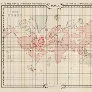
WORLD MAP / 1897
Map of the world showing British Empire possessions
Mary Evans Picture Library makes available wonderful images created for people to enjoy over the centuries
Media ID 585188
© Mary Evans Picture Library 2015 - https://copyrighthub.org/s0/hub1/creation/maryevans/MaryEvansPictureID/10039195
1897 Colonialism Imperialism Possessions
Jigsaw Puzzle (252 Pieces)
Discover the rich history of the British Empire with our captivating jigsaw puzzle from the Media Storehouse collection. Featuring an intricately detailed World Map from the Mary Evans Picture Library, dated 1897, this puzzle offers an engaging and educational experience for all ages. Explore the expansive territories of the British Empire as it once existed, piecing together this stunning representation of geopolitical history. Immerse yourself in the intricacies of this puzzle and unveil the captivating story of a bygone era. Perfect for history enthusiasts, puzzle lovers, or anyone seeking a challenging and rewarding pastime.
Made in the USA, 252-piece puzzles measure 11" x 14" (27.9 x 35.5 cm). Every puzzle is meticulously printed on glossy photo paper, which has a strong 1.33 mm thickness. Delivered in a black storage cardboard box, these puzzles are both stylish and practical. (Note: puzzles contain small parts and are not suitable for children under 3 years of age.)
Jigsaw Puzzles are an ideal gift for any occasion
Estimated Product Size is 35.6cm x 28cm (14" x 11")
These are individually made so all sizes are approximate
Artwork printed orientated as per the preview above, with landscape (horizontal) orientation to match the source image.
FEATURES IN THESE COLLECTIONS
> Maps and Charts
> British Empire Maps
> Maps and Charts
> Early Maps
> Maps and Charts
> World
> Mary Evans Prints Online
> Maps
EDITORS COMMENTS
This stunning print of a world map from 1897 offers a fascinating glimpse into the era of imperialism and colonialism. The map vividly displays the vast extent of the British Empire's possessions at the height of its power, showcasing territories spread across continents and oceans.
Each shaded region on the map represents an area under British control, highlighting the global reach and influence of this once mighty empire. From India to Africa to Australia, the British Empire's presence is unmistakable, with each possession symbolizing a complex history of conquest, exploitation, and cultural exchange.
As we study this historical map, we are reminded of the political dynamics that shaped our modern world. The lines drawn on this map reflect not just geographical boundaries but also centuries-old power struggles and conflicts between nations. It serves as a visual reminder of how imperialism reshaped societies and landscapes around the globe.
This print is not just a decorative piece but also a valuable educational tool for understanding our shared history. It prompts us to reflect on past injustices while also appreciating the interconnectedness of our world today. A truly captivating piece that invites viewers to explore both geography and politics through a historical lens.
MADE IN THE USA
Safe Shipping with 30 Day Money Back Guarantee
FREE PERSONALISATION*
We are proud to offer a range of customisation features including Personalised Captions, Color Filters and Picture Zoom Tools
SECURE PAYMENTS
We happily accept a wide range of payment options so you can pay for the things you need in the way that is most convenient for you
* Options may vary by product and licensing agreement. Zoomed Pictures can be adjusted in the Cart.