Home > Europe > France > Canton > Bas Rhin
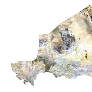
Myanmar, Relief Map

![]()
Wall Art and Photo Gifts from Universal Images Group (UIG)
Myanmar, Relief Map
Relief map of Myanmar. This map was processed from elevation data
Universal Images Group (UIG) manages distribution for many leading specialist agencies worldwide
Media ID 9608701
© Planet Observer
Alsace Bas Rhin Geographical Border Relief Map Satellite View
FEATURES IN THESE COLLECTIONS
> Europe
> France
> Canton
> Bas Rhin
> Europe
> France
> Canton
> Rhin
> Universal Images Group (UIG)
> Universal Images Group
> Satellite and Aerial
> Planet Observer 6
EDITORS COMMENTS
This print showcases the intricate relief map of Myanmar, offering a mesmerizing glimpse into the country's diverse topography. Processed from elevation data, this map beautifully illustrates the varying altitudes and geographical features that define Myanmar's landscape. From soaring mountain ranges to sprawling plains, every contour is meticulously captured in this stunning image. The vibrant colors and sharp details bring this relief map to life, making it an ideal piece for any geography enthusiast or lover of cartography. With no people in sight, the focus remains solely on the natural beauty and geographical borders that shape Myanmar's terrain. Taken from a satellite view perspective, this photograph provides a unique opportunity to explore Myanmar's physical geography from above. The absence of commercial use ensures an authentic representation of the country's landforms without distractions or alterations. Whether you are interested in studying geographic patterns or simply appreciate visually striking imagery, this print offers both educational value and aesthetic appeal. Hang it on your wall as a conversation starter or use it as a reference tool for understanding Myanmar's diverse landscapes – either way, you'll be transported to this enchanting corner of Southeast Asia with just one glance at this remarkable relief map photograph by Universal Images Group (UIG).
MADE IN THE USA
Safe Shipping with 30 Day Money Back Guarantee
FREE PERSONALISATION*
We are proud to offer a range of customisation features including Personalised Captions, Color Filters and Picture Zoom Tools
SECURE PAYMENTS
We happily accept a wide range of payment options so you can pay for the things you need in the way that is most convenient for you
* Options may vary by product and licensing agreement. Zoomed Pictures can be adjusted in the Cart.