Home > Europe > France > Canton > Bas Rhin
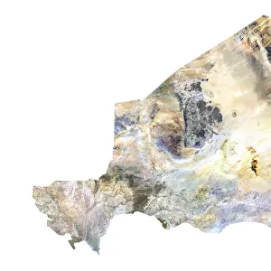
Jordan, Satellite Image

![]()
Wall Art and Photo Gifts from Universal Images Group (UIG)
Jordan, Satellite Image
Satellite view of Jordan. This image was compiled from data acquired by LANDSAT satellite
Universal Images Group (UIG) manages distribution for many leading specialist agencies worldwide
Media ID 9617977
© Planet Observer
Alsace Bas Rhin Geographical Border Relief Map Satellite View
FEATURES IN THESE COLLECTIONS
> Europe
> France
> Canton
> Bas Rhin
> Europe
> France
> Canton
> Rhin
> Universal Images Group (UIG)
> Universal Images Group
> Satellite and Aerial
> Planet Observer 6
EDITORS COMMENTS
This print showcases the stunning satellite view of Jordan, a country steeped in rich history and natural beauty. Compiled from data acquired by the LANDSAT satellite, this image offers a unique perspective on Jordan's topography and geographical features. The vibrant colors and intricate details bring to life the diverse landscapes that make up this enchanting Middle Eastern nation. From the towering peaks of the majestic mountains to the vast deserts stretching into infinity, every contour is meticulously captured in this photograph. The absence of human presence allows us to fully appreciate nature's grandeur as we explore Jordan's physical geography through this aerial lens. The relief map displayed here highlights both subtle nuances and dramatic variations in elevation across different regions of Jordan. As our eyes traverse its borders, we are reminded of how interconnected landforms shape a country's identity. With Europe visible in the background, this image serves as a reminder of Jordan's strategic location bridging continents. It invites us to ponder upon historical trade routes that have shaped civilizations throughout centuries. Universal Images Group (UIG) has once again presented an awe-inspiring visual masterpiece with their meticulous cartography skills. This print is not only an artistic marvel but also an educational tool for those intrigued by geography or simply captivated by Earth’s wonders
MADE IN THE USA
Safe Shipping with 30 Day Money Back Guarantee
FREE PERSONALISATION*
We are proud to offer a range of customisation features including Personalised Captions, Color Filters and Picture Zoom Tools
SECURE PAYMENTS
We happily accept a wide range of payment options so you can pay for the things you need in the way that is most convenient for you
* Options may vary by product and licensing agreement. Zoomed Pictures can be adjusted in the Cart.