Home > Europe > France > Canton > Bas Rhin
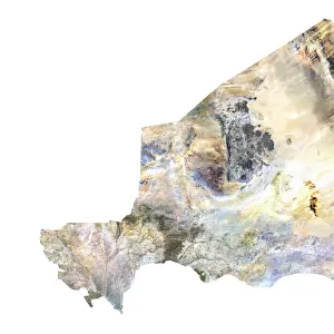
Iraq, Satellite Image

![]()
Wall Art and Photo Gifts from Universal Images Group (UIG)
Iraq, Satellite Image
Satellite view of Iraq. This image was compiled from data acquired by LANDSAT satellite
Universal Images Group (UIG) manages distribution for many leading specialist agencies worldwide
Media ID 9618071
© Planet Observer
Alsace Bas Rhin Geographical Border Relief Map Satellite View
FEATURES IN THESE COLLECTIONS
> Europe
> France
> Canton
> Bas Rhin
> Europe
> France
> Canton
> Rhin
> Universal Images Group (UIG)
> Universal Images Group
> Satellite and Aerial
> Planet Observer 6
EDITORS COMMENTS
This print showcases the stunning satellite view of Iraq, a country steeped in rich history and diverse landscapes. Compiled from data acquired by the LANDSAT satellite, this image offers a unique perspective on Iraq's topography and geographical borders. The vibrant colors and intricate details bring to life the physical geography of this ancient land. From the soaring peaks of its mountain ranges to the vast expanse of its deserts, Iraq's natural beauty is beautifully captured in this photograph. With no people present, it allows us to focus solely on appreciating the sheer magnificence of its terrain. This image serves as a testament to both human ingenuity in capturing such remarkable views from space and nature's awe-inspiring creations. As we gaze upon this vertical composition, our eyes are drawn towards every contour and feature that defines Iraq's landscape. It invites us to explore further into its depths, igniting curiosity about what lies beyond what meets the eye. While not mentioning commercial use or affiliations with any specific company, this print stands as an artistic representation rather than just a mere map or relief model. It reminds us that even through technology like satellites, we can still marvel at Earth's wonders from afar. Whether you are an enthusiast of cartography or simply appreciate breathtaking photography showcasing our planet's diversity, this Universal Images Group (UIG) print will undoubtedly captivate your imagination and inspire wanderlust for exploring Iraq’s enchanting terrains firsthand.
MADE IN THE USA
Safe Shipping with 30 Day Money Back Guarantee
FREE PERSONALISATION*
We are proud to offer a range of customisation features including Personalised Captions, Color Filters and Picture Zoom Tools
SECURE PAYMENTS
We happily accept a wide range of payment options so you can pay for the things you need in the way that is most convenient for you
* Options may vary by product and licensing agreement. Zoomed Pictures can be adjusted in the Cart.