Home > Europe > France > Heritage Sites > Mont-Saint-Michel and its Bay
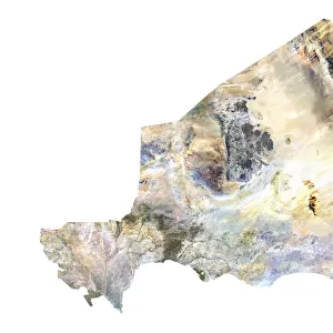
Departement of Manche, France, Relief Map

![]()
Wall Art and Photo Gifts from Universal Images Group (UIG)
Departement of Manche, France, Relief Map
Relief map of the departement of Manche in Lower Normandy, France. It includes the Cotentin peninsula down to the famous Mont Saint-Michel. This image was compiled from data acquired by LANDSAT 5 & 7 satellites combined with elevation data
Universal Images Group (UIG) manages distribution for many leading specialist agencies worldwide
Media ID 9612339
© Planet Observer
Alsace Bas Rhin Geographical Border Relief Map Satellite View
FEATURES IN THESE COLLECTIONS
> Europe
> France
> Canton
> Bas Rhin
> Europe
> France
> Canton
> Manche
> Europe
> France
> Canton
> Rhin
> Europe
> France
> Heritage Sites
> Mont-Saint-Michel and its Bay
> Universal Images Group (UIG)
> Universal Images Group
> Satellite and Aerial
> Planet Observer 6
EDITORS COMMENTS
This stunning print showcases the breathtaking relief map of the Departement of Manche in Lower Normandy, France. Capturing the essence of this picturesque region, the image encompasses the Cotentin peninsula and extends all the way to the iconic Mont Saint-Michel. Created using a combination of data acquired by LANDSAT 5 & 7 satellites along with elevation data, this masterpiece offers a unique perspective on the topography and physical geography of Manche. The vibrant colors and intricate details bring this relief map to life, allowing viewers to immerse themselves in its beauty. With no people present in the photograph, one can truly appreciate nature's artistry at its finest. The geographical borders are clearly defined, providing an accurate representation of Manche's boundaries. As we gaze upon this vertical shot taken from above, it becomes evident that cartography is indeed an art form. The careful compilation of satellite imagery has resulted in a visually striking portrayal that highlights both natural wonders and man-made features within Manche. Whether you are an avid traveler or simply fascinated by maps and landscapes, this print serves as a captivating piece for any collection. It transports us to Europe's charming Alsace region while offering insight into its diverse terrain. This remarkable creation from Universal Images Group (UIG) is not only aesthetically pleasing but also educational – reminding us once again how interconnected our world truly is through technology and exploration.
MADE IN THE USA
Safe Shipping with 30 Day Money Back Guarantee
FREE PERSONALISATION*
We are proud to offer a range of customisation features including Personalised Captions, Color Filters and Picture Zoom Tools
SECURE PAYMENTS
We happily accept a wide range of payment options so you can pay for the things you need in the way that is most convenient for you
* Options may vary by product and licensing agreement. Zoomed Pictures can be adjusted in the Cart.