Home > Europe > France > Canton > Charente
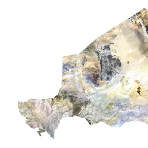
Departement of Charente-Maritime, France, True Colour Satellite Image

![]()
Wall Art and Photo Gifts from Universal Images Group (UIG)
Departement of Charente-Maritime, France, True Colour Satellite Image
Satellite view of the departement of Charente-Maritime in Poitou-Charentes, France. It includes the islands of Ile de Re, Ile d Aix and Ile d Oleron. This image was compiled from data acquired by LANDSAT 5 & 7 satellites
Universal Images Group (UIG) manages distribution for many leading specialist agencies worldwide
Media ID 9618265
© Planet Observer
Alsace Bas Rhin Geographical Border Relief Map Satellite View
FEATURES IN THESE COLLECTIONS
> Europe
> France
> Canton
> Bas Rhin
> Europe
> France
> Canton
> Charente
> Europe
> France
> Canton
> Rhin
> Universal Images Group (UIG)
> Universal Images Group
> Satellite and Aerial
> Planet Observer 6
EDITORS COMMENTS
This print showcases the breathtaking beauty of the Departement of Charente-Maritime in Poitou-Charentes, France. With its true color satellite image, it provides a mesmerizing view of this picturesque region. The image encompasses not only the mainland but also includes the enchanting islands of Ile de Re, Ile d Aix, and Ile d Oleron. Compiled from data acquired by LANDSAT 5 & 7 satellites, this aerial perspective offers a unique glimpse into the topography and physical geography of Charente-Maritime. The vibrant colors bring to life every intricate detail, allowing us to appreciate the geographical borders and relief map that define this area. As we explore this photograph further, we are reminded of Europe's diverse landscapes and natural wonders. This vertical shot captures an expansive outdoor scene without any human presence, emphasizing nature's dominance in shaping these lands. The artistry behind cartography is evident as each element seamlessly merges together to create a visually stunning composition. It serves as both an informative tool for understanding geographic features and a work of art that evokes awe-inspiring emotions
MADE IN THE USA
Safe Shipping with 30 Day Money Back Guarantee
FREE PERSONALISATION*
We are proud to offer a range of customisation features including Personalised Captions, Color Filters and Picture Zoom Tools
SECURE PAYMENTS
We happily accept a wide range of payment options so you can pay for the things you need in the way that is most convenient for you
* Options may vary by product and licensing agreement. Zoomed Pictures can be adjusted in the Cart.