Home > Europe > France > Canton > Bas Rhin
Canvas Print : Burundi, Relief Map


![]()
Canvas Prints from Universal Images Group (UIG)
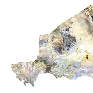
Burundi, Relief Map
Relief map of Burundi. This map was processed from elevation data
Universal Images Group (UIG) manages distribution for many leading specialist agencies worldwide
Media ID 9634039
© Planet Observer
Alsace Bas Rhin Geographical Border Relief Map Satellite View
20"x16" (51x41cm) Canvas Print
Discover the beauty and complexity of Burundi with our Canvas Prints from Media Storehouse. Featuring an intricately detailed relief map of this African country, sourced from Universal Images Group (UIG), these prints bring geography to life. Each canvas is expertly crafted with high-quality materials, ensuring vibrant colors and sharp details that truly represent the terrain of Burundi. Elevate your home or office decor with this unique and educational piece, perfect for geography enthusiasts or those with a connection to the region. Order your Burundi Relief Map Canvas Print today and bring a piece of the world into your space.
Delivered stretched and ready to hang our premium quality canvas prints are made from a polyester/cotton blend canvas and stretched over a 1.25" (32mm) kiln dried knot free wood stretcher bar. Packaged in a plastic bag and secured to a cardboard insert for safe transit.
Canvas Prints add colour, depth and texture to any space. Professionally Stretched Canvas over a hidden Wooden Box Frame and Ready to Hang
Estimated Product Size is 40.6cm x 50.8cm (16" x 20")
These are individually made so all sizes are approximate
Artwork printed orientated as per the preview above, with portrait (vertical) orientation to match the source image.
FEATURES IN THESE COLLECTIONS
> Africa
> Burundi
> Related Images
> Europe
> France
> Canton
> Bas Rhin
> Europe
> France
> Canton
> Rhin
> Universal Images Group (UIG)
> Universal Images Group
> Satellite and Aerial
> Planet Observer 6
EDITORS COMMENTS
This print showcases the stunning relief map of Burundi, a landlocked country nestled in the heart of Africa. The intricate details and precision of this map are truly remarkable, as it has been meticulously processed from elevation data. Every contour and feature of Burundi's topography is beautifully depicted, allowing viewers to immerse themselves in its diverse landscapes. The vibrant colors used in this image bring life to the geographical borders and highlight the varying elevations across the region. From lush green valleys to towering mountains, this relief map provides a visual representation of Burundi's physical geography like never before. Captured from a satellite view, this photograph perfectly captures the essence of cartography and showcases how technology can enhance our understanding of different regions around the world. With no people present in the frame, all attention is drawn towards appreciating nature's wonders and exploring Burundi's unique terrain. As part of Universal Images Group (UIG), renowned for their exceptional photography collection, this print exemplifies their commitment to capturing extraordinary moments that educate and inspire. It is important to note that this caption does not mention any commercial use or affiliation with any specific company; instead, it focuses on celebrating the beauty and significance behind this particular photograph from UIG.
MADE IN THE USA
Safe Shipping with 30 Day Money Back Guarantee
FREE PERSONALISATION*
We are proud to offer a range of customisation features including Personalised Captions, Color Filters and Picture Zoom Tools
SECURE PAYMENTS
We happily accept a wide range of payment options so you can pay for the things you need in the way that is most convenient for you
* Options may vary by product and licensing agreement. Zoomed Pictures can be adjusted in the Cart.