Home > Asia > Japan > Sendai
Photographic Print : Region of Tohoku, Japan, Relief Map


![]()
Photo Prints from Universal Images Group (UIG)
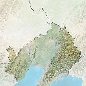
Region of Tohoku, Japan, Relief Map
Relief map of the region of Tohoku, Japan. This image was compiled from data acquired by LANDSAT 5 & 7 satellites combined with elevation data
Universal Images Group (UIG) manages distribution for many leading specialist agencies worldwide
Media ID 9618727
© Planet Observer/UIG
Coastline Honshu Japan Region Relief Map Shore Fukushima Satellite View Sendai Tohoku
14"x11" Photo Print
Discover the intricacies of the Tohoku region in Japan with our Media Storehouse Photographic Print of the Relief Map. Meticulously crafted using data from LANDSAT 5 & 7 satellites, this stunning visual representation showcases the dynamic topography of the area. Elevation data brings a new dimension to your understanding of the landscape, making this print an essential addition to any home or office. Explore the beauty and complexity of Tohoku like never before with Media Storehouse's high-quality, detailed photographic prints.
Photo prints are produced on Kodak professional photo paper resulting in timeless and breath-taking prints which are also ideal for framing. The colors produced are rich and vivid, with accurate blacks and pristine whites, resulting in prints that are truly timeless and magnificent. Whether you're looking to display your prints in your home, office, or gallery, our range of photographic prints are sure to impress. Dimensions refers to the size of the paper in inches.
Our Photo Prints are in a large range of sizes and are printed on Archival Quality Paper for excellent colour reproduction and longevity. They are ideal for framing (our Framed Prints use these) at a reasonable cost. Alternatives include cheaper Poster Prints and higher quality Fine Art Paper, the choice of which is largely dependant on your budget.
Estimated Image Size (if not cropped) is 25.1cm x 35.5cm (9.9" x 14")
Estimated Product Size is 27.9cm x 35.5cm (11" x 14")
These are individually made so all sizes are approximate
Artwork printed orientated as per the preview above, with portrait (vertical) orientation to match the source image.
FEATURES IN THESE COLLECTIONS
> Asia
> Japan
> Related Images
> Universal Images Group (UIG)
> Universal Images Group
> Satellite and Aerial
> Planet Observer 4
EDITORS COMMENTS
This print showcases the breathtaking region of Tohoku, Japan, in all its natural glory. The relief map, compiled from data acquired by LANDSAT 5 & 7 satellites combined with elevation data, offers a unique perspective on the topography of this stunning area. With its vibrant colors and intricate details, the image brings to life the physical geography of Tohoku. Stretching along the eastern coastline of Honshu, Japan's largest island, Tohoku is known for its diverse landscapes and picturesque shorelines. This photograph beautifully captures the rugged beauty of this region as it merges seamlessly with the vast Pacific Ocean. The absence of people in this image allows us to focus solely on nature's grandeur. From lush green mountains to winding rivers and sprawling plains, every contour is meticulously depicted on this relief map. As we explore further into this visual masterpiece, our eyes are drawn towards Fukushima and Sendai - prominent cities that have become symbols of resilience after facing adversity. Through cartography and satellite view technology, Universal Images Group (UIG) has created an awe-inspiring representation that invites viewers to immerse themselves in Tohoku's enchanting landscape. Whether you are a lover of photography or simply fascinated by Asia's wonders, this print serves as a reminder that Earth's beauty knows no bounds.
MADE IN THE USA
Safe Shipping with 30 Day Money Back Guarantee
FREE PERSONALISATION*
We are proud to offer a range of customisation features including Personalised Captions, Color Filters and Picture Zoom Tools
SECURE PAYMENTS
We happily accept a wide range of payment options so you can pay for the things you need in the way that is most convenient for you
* Options may vary by product and licensing agreement. Zoomed Pictures can be adjusted in the Cart.