Home > North America > Canada > Ottawa
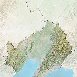
Province of Ontario, Canada, Relief Map

![]()
Wall Art and Photo Gifts from Universal Images Group (UIG)
Province of Ontario, Canada, Relief Map
Relief map of Ontario, Canada. This image was compiled from data acquired by LANDSAT 5 & 7 satellites combined with elevation data
Universal Images Group (UIG) manages distribution for many leading specialist agencies worldwide
Media ID 9613381
© Planet Observer/UIG
Canada Coastline Great Lakes Hudson Bay Lake Ontario Ottawa Province Relief Map Shore Toronto Satellite View
FEATURES IN THESE COLLECTIONS
> Aerial Photography
> America
> North America
> Canada
> Lakes
> Related Images
> North America
> Canada
> Maps
> North America
> Canada
> Ottawa
> North America
> Canada
> Toronto
> Universal Images Group (UIG)
> Universal Images Group
> Satellite and Aerial
> Planet Observer 4
MADE IN THE USA
Safe Shipping with 30 Day Money Back Guarantee
FREE PERSONALISATION*
We are proud to offer a range of customisation features including Personalised Captions, Color Filters and Picture Zoom Tools
SECURE PAYMENTS
We happily accept a wide range of payment options so you can pay for the things you need in the way that is most convenient for you
* Options may vary by product and licensing agreement. Zoomed Pictures can be adjusted in the Cart.