Home > Europe > United Kingdom > Northern Ireland > Maps
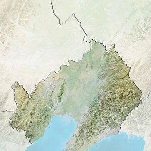
Northern Ireland, United Kingdom, True Colour Satellite Image

![]()
Wall Art and Photo Gifts from Universal Images Group (UIG)
Northern Ireland, United Kingdom, True Colour Satellite Image
Satellite view of Northern Ireland, United Kingdom. This image was compiled from data acquired by LANDSAT 5 & 7 satellites
Universal Images Group (UIG) manages distribution for many leading specialist agencies worldwide
Media ID 9618545
© Planet Observer/UIG
Belfast Coastline Island Northern Ireland Shore United Kingdom Satellite View
FEATURES IN THESE COLLECTIONS
> Aerial Photography
> Ireland
> Europe
> Republic of Ireland
> Maps
> Europe
> United Kingdom
> Northern Ireland
> Belfast
> Europe
> United Kingdom
> Northern Ireland
> Maps
> Universal Images Group (UIG)
> Universal Images Group
> Satellite and Aerial
> Planet Observer 4
EDITORS COMMENTS
This print showcases the stunning true colors of Northern Ireland, United Kingdom, as seen from a satellite's perspective. Compiled from data acquired by LANDSAT 5 & 7 satellites, this image offers a unique and detailed view of the island's topography and coastline. The vibrant hues beautifully highlight the diverse landscapes that grace this region. From the bustling cityscape of Belfast to the serene shores that line its perimeter, every corner of Northern Ireland is captured in this horizontal photograph. Its physical geography is laid bare for all to see, revealing mountains, valleys, rivers, and lakes that shape its remarkable terrain. The absence of people in this picture allows us to focus solely on nature's grandeur. It invites viewers to immerse themselves in the untamed beauty found within these borders. As we gaze upon this color image with awe-inspiring clarity, it becomes evident why Northern Ireland has long been an inspiration for photographers and explorers alike. Through cartography and satellite technology combined with artistic vision, Universal Images Group (UIG) presents us with an extraordinary visual representation of one of Europe's most enchanting regions. This print serves as a testament to mankind's ability to capture Earth's wonders through innovation while reminding us how small we are compared to nature’s vastness
MADE IN THE USA
Safe Shipping with 30 Day Money Back Guarantee
FREE PERSONALISATION*
We are proud to offer a range of customisation features including Personalised Captions, Color Filters and Picture Zoom Tools
SECURE PAYMENTS
We happily accept a wide range of payment options so you can pay for the things you need in the way that is most convenient for you
* Options may vary by product and licensing agreement. Zoomed Pictures can be adjusted in the Cart.