Home > Aerial Photography > Related Images
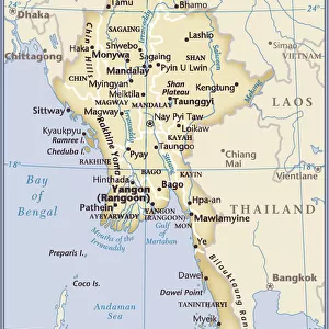
Myanmar, Relief Map With Border and Mask

![]()
Wall Art and Photo Gifts from Universal Images Group (UIG)
Myanmar, Relief Map With Border and Mask
Relief map of Myanmar (with border and mask). This image was compiled from data acquired by landsat 5 & 7 satellites combined with elevation data
Universal Images Group (UIG) manages distribution for many leading specialist agencies worldwide
Media ID 9618821
© Planet Observer/UIG
Bay Of Bengal Burma Coastline Myanmar Rangoon Relief Map Shore Andaman Sea Irrawaddy River Satellite View
FEATURES IN THESE COLLECTIONS
> Aerial Photography
> Related Images
> Universal Images Group (UIG)
> Universal Images Group
> Satellite and Aerial
> Planet Observer 4
EDITORS COMMENTS
This print showcases the stunning relief map of Myanmar, a country known for its rich history and breathtaking landscapes. Compiled from data acquired by Landsat 5 & 7 satellites combined with elevation data, this image offers a unique perspective on the topography and physical geography of Myanmar. The intricate details of the relief map are beautifully captured in this vertical photograph, highlighting the diverse features that make up this enchanting nation. From the serene shores along the Andaman Sea to the majestic Bay of Bengal, every contour and coastline is meticulously depicted. Notably, the mighty Irrawaddy River winds its way through the heartland of Myanmar, adding an element of dynamism to this already mesmerizing scene. The absence of people allows us to fully appreciate nature's grandeur as it unfolds before our eyes. As we gaze upon this remarkable cartographic masterpiece, we can't help but be transported to distant lands filled with mystery and wonder. The vibrant colors bring life to each mountain range and valley while emphasizing Myanmar's unique beauty. Whether you are an avid traveler or simply fascinated by geography, this print serves as a visual feast for all who admire artistry intertwined with scientific precision. It is a testament to both human ingenuity in satellite technology and Mother Nature's awe-inspiring creations.
MADE IN THE USA
Safe Shipping with 30 Day Money Back Guarantee
FREE PERSONALISATION*
We are proud to offer a range of customisation features including Personalised Captions, Color Filters and Picture Zoom Tools
SECURE PAYMENTS
We happily accept a wide range of payment options so you can pay for the things you need in the way that is most convenient for you
* Options may vary by product and licensing agreement. Zoomed Pictures can be adjusted in the Cart.