Home > Africa > Algeria > Maps
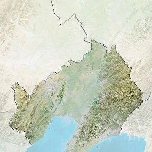
Algeria, Relief Map With Border and Mask

![]()
Wall Art and Photo Gifts from Universal Images Group (UIG)
Algeria, Relief Map With Border and Mask
Relief map of Algeria (with border and mask). This image was compiled from data acquired by landsat 5 & 7 satellites combined with elevation data
Universal Images Group (UIG) manages distribution for many leading specialist agencies worldwide
Media ID 9613241
© Planet Observer/UIG
Africa Algeria Algiers Coastline Desert Mediterranean Sea Mountain Mountain Range Relief Map Sahara Shore Snow Atlas Mountains Satellite View
FEATURES IN THESE COLLECTIONS
> Universal Images Group (UIG)
> Universal Images Group
> Satellite and Aerial
> Planet Observer 4
EDITORS COMMENTS
This print showcases the stunning relief map of Algeria, revealing its diverse and breathtaking landscapes. Compiled from data acquired by landsat 5 & 7 satellites combined with elevation data, this image offers a comprehensive view of Algeria's topography. From majestic mountains to vast deserts and picturesque shores, the country's natural beauty is on full display. The photograph captures the essence of Algeria's physical geography in exquisite detail. The rugged mountain ranges, such as the Atlas Mountains, stand tall against the horizon, while the Sahara Desert stretches endlessly towards the south. The Mediterranean Sea borders one side of this North African nation, adding a touch of tranquility to its dynamic landscape. Notably absent from this image are any signs of human presence. Instead, nature takes center stage as it unfolds before our eyes. Snow-capped peaks contrast with arid desert dunes and rocky coastlines create an intriguing juxtaposition between land and sea. Through cartography and satellite imagery techniques, Universal Images Group (UIG) has transformed raw data into a visually striking representation that highlights both the grandeur and fragility of Algeria's environment. Whether you are fascinated by physical geography or simply drawn to Africa's allure, this horizontal photograph invites you to explore every inch of Algeria's remarkable terrain without leaving your own space.
MADE IN THE USA
Safe Shipping with 30 Day Money Back Guarantee
FREE PERSONALISATION*
We are proud to offer a range of customisation features including Personalised Captions, Color Filters and Picture Zoom Tools
SECURE PAYMENTS
We happily accept a wide range of payment options so you can pay for the things you need in the way that is most convenient for you
* Options may vary by product and licensing agreement. Zoomed Pictures can be adjusted in the Cart.