Home > Europe > United Kingdom > England > London > Sights > St Pauls Cathedral
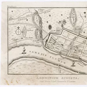
Plan of London around St. Pauls in 1563. After Ralph Agass map

![]()
Wall Art and Photo Gifts from Universal Images Group (UIG)
Plan of London around St. Pauls in 1563. After Ralph Agass map
Plan of London around St. Pauls in 1563. After Ralph Agass map. From London Pictures, published 1890
Universal Images Group (UIG) manages distribution for many leading specialist agencies worldwide
Media ID 20165181
© Design Pics / Hilary Jane Morgan
1563 16th Century Archival Archive Pauls Ralph Agas Saint Pauls
FEATURES IN THESE COLLECTIONS
> Arts
> Artists
> A
> Ralph Agas
> Europe
> United Kingdom
> England
> London
> Sights
> St Pauls Cathedral
> Europe
> United Kingdom
> England
> Maps
> Universal Images Group (UIG)
> History
> Historical Maps
EDITORS COMMENTS
This print showcases the intricate "Plan of London around St. Paul's in 1563" meticulously recreated after Ralph Agas' original map. Published in 1890 as part of the esteemed collection, "London Pictures" this archival piece takes us on a journey back to the vibrant streets of 16th century England. As we delve into this historical illustration, we are transported to a bygone era where bustling markets and narrow alleyways defined the cityscape. The detailed depiction allows us to explore every nook and cranny surrounding St. Paul's Cathedral, an iconic landmark that has stood tall for centuries. The artist, Hilary Jane Morgan, expertly captures the essence of old London through her skillful interpretation of Agas' map. Every street corner and building is brought to life with remarkable precision, offering a glimpse into daily life during this significant period in English history. This archival gem not only serves as a visual feast for history enthusiasts but also acts as a valuable resource for researchers and scholars seeking insights into London's past. It reminds us of how cities evolve over time while preserving their rich heritage. Through this print from Universal Images Group (UIG), we are reminded that history is not just confined within textbooks; it can be experienced through art and imagery too.
MADE IN THE USA
Safe Shipping with 30 Day Money Back Guarantee
FREE PERSONALISATION*
We are proud to offer a range of customisation features including Personalised Captions, Color Filters and Picture Zoom Tools
SECURE PAYMENTS
We happily accept a wide range of payment options so you can pay for the things you need in the way that is most convenient for you
* Options may vary by product and licensing agreement. Zoomed Pictures can be adjusted in the Cart.