Home > Asia > Hong Kong > Maps
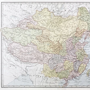
China, Relief Map With Border and Mask

![]()
Wall Art and Photo Gifts from Universal Images Group (UIG)
China, Relief Map With Border and Mask
Relief map of China (with border and mask). This image was compiled from data acquired by landsat 5 & 7 satellites combined with elevation data
Universal Images Group (UIG) manages distribution for many leading specialist agencies worldwide
Media ID 9619083
© Planet Observer/UIG
Beijing China Coastline Desert Gobi Desert Himalayas Hong Kong Mountain Mountain Range Relief Map Shanghai Shore Snow Taiwan Tibet Mount Everest Satellite View Yangtze River Yellow River
FEATURES IN THESE COLLECTIONS
> Aerial Photography
> Related Images
> Universal Images Group (UIG)
> Universal Images Group
> Satellite and Aerial
> Planet Observer 4
EDITORS COMMENTS
This print showcases the intricate topography of China, offering a mesmerizing glimpse into its diverse landscapes. The relief map, compiled from data acquired by landsat 5 & 7 satellites combined with elevation data, presents an incredibly detailed representation of this vast country. From the majestic mountain ranges to the sprawling deserts and serene shores, China's natural beauty is on full display in this image. The towering peaks of Tibet and the Himalayas stand tall against the backdrop of clear blue skies, while the Gobi Desert stretches out endlessly in golden hues. The meandering paths of rivers like the Yellow River and Yangtze River carve their way through valleys and plains, adding a touch of serenity to this dynamic landscape. The bustling cities are also highlighted in this photo print; Beijing with its rich history and iconic landmarks such as the Great Wall can be spotted along with Shanghai's modern skyline. Even Taiwan makes an appearance on this comprehensive map. With no people visible in sight, one can truly appreciate nature's grandeur showcased here. This horizontal photograph captures every detail meticulously - from snow-capped peaks to coastal outlines - making it a remarkable piece for anyone interested in physical geography or cartography
MADE IN THE USA
Safe Shipping with 30 Day Money Back Guarantee
FREE PERSONALISATION*
We are proud to offer a range of customisation features including Personalised Captions, Color Filters and Picture Zoom Tools
SECURE PAYMENTS
We happily accept a wide range of payment options so you can pay for the things you need in the way that is most convenient for you
* Options may vary by product and licensing agreement. Zoomed Pictures can be adjusted in the Cart.