Home > Europe > France > Paris > Maps
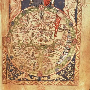
Map of Sicily, or the Kingdom of Naples by Giovanni Antonio Rizzi-Zannoni, copperplate, printed in Paris circa 1691-1693

![]()
Wall Art and Photo Gifts from Universal Images Group (UIG)
Map of Sicily, or the Kingdom of Naples by Giovanni Antonio Rizzi-Zannoni, copperplate, printed in Paris circa 1691-1693
Cartography, Italy, 18th century. Map of Sicily (or the Kingdom of Naples) commissioned by the King of the Two Sicilies. Created by Giovanni Antonio Rizzi-Zannoni, Paris 1691-1693 ca. Copperplate 150 x 135 cm
Universal Images Group (UIG) manages distribution for many leading specialist agencies worldwide
Media ID 9455195
© DEA PICTURE LIBRARY
17th Century Coastline Copperplate Direction Guidance Overhead View Western Script Kingdom Of Naples Mediterrean Sea
FEATURES IN THESE COLLECTIONS
> Europe
> France
> Paris
> Maps
> Europe
> Italy
> Campania
> Naples
> Europe
> Italy
> Sculptures
> Europe
> Italy
> Sicily
> Related Images
> Universal Images Group (UIG)
> Art
> Painting, Sculpture & Prints
> Illustration And Painting
EDITORS COMMENTS
This stunning print showcases a magnificent map of Sicily, or the Kingdom of Naples, created by the talented cartographer Giovanni Antonio Rizzi-Zannoni in Paris around 1691-1693. Commissioned by the King of the Two Sicilies, this copperplate masterpiece measures an impressive 150 x 135 cm. The intricate details and exquisite craftsmanship of this artwork transport us back to Italy's rich history during the 17th century. With its vertical orientation and overhead view, it offers a comprehensive guide for travelers seeking direction and exploration within these ancient lands. The map not only depicts physical geography but also highlights the importance of sea routes along the coastline. The Mediterranean Sea plays a significant role in connecting various regions within this kingdom. Rizzi-Zannoni's artistry shines through as he skillfully combines illustration and painting techniques to create a visually captivating piece. This print captures every minute detail with precision, allowing us to appreciate his mastery even centuries later. As we gaze upon this remarkable work, we are reminded of how maps have served as invaluable tools throughout history—guiding explorers, merchants, and adventurers alike. It serves as a testament to human curiosity and our desire to understand our surroundings. With no people depicted on this map, it invites us to imagine ourselves embarking on journeys across time and space—a window into an era long gone yet forever preserved through art.
MADE IN THE USA
Safe Shipping with 30 Day Money Back Guarantee
FREE PERSONALISATION*
We are proud to offer a range of customisation features including Personalised Captions, Color Filters and Picture Zoom Tools
SECURE PAYMENTS
We happily accept a wide range of payment options so you can pay for the things you need in the way that is most convenient for you
* Options may vary by product and licensing agreement. Zoomed Pictures can be adjusted in the Cart.