Home > Architecture > Country > Italy > Naples
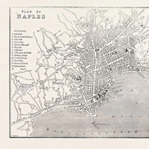
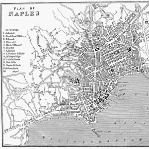
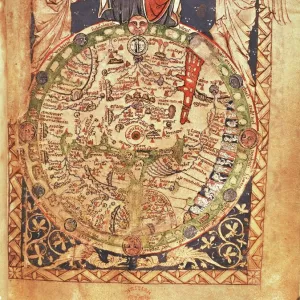
Map of Naples and its Main Buildings, Map of Gaeta, by Christoph Homann, copperplate, printed in Nuremberg, 1727

![]()
Wall Art and Photo Gifts from Universal Images Group (UIG)
Map of Naples and its Main Buildings, Map of Gaeta, by Christoph Homann, copperplate, printed in Nuremberg, 1727
Cartography, Italy, 18th century. Map of Naples and its main buildings, map of Gaeta, by Christoph Homann, Nuremberg 1727. Copperplate 49.5 x 65 cm
Universal Images Group (UIG) manages distribution for many leading specialist agencies worldwide
Media ID 9455189
© DEA PICTURE LIBRARY
Background People City Cityscape Coastline Copperplate Direction Guidance Multiple Image Naples Western Script 1727 Gaeta Mediterrean Sea
FEATURES IN THESE COLLECTIONS
> Architecture
> Country
> Italy
> Naples
> Arts
> Art Movements
> Landscapes
> Arts
> Contemporary art
> Landscapes
> Sculptures
> Arts
> Contemporary art
> Sculpture
> Landscape paintings
> Arts
> Landscape paintings
> Cityscape art
> Landscape paintings
> Arts
> Landscape paintings
> Cityscape art
> Arts
> Landscape paintings
> Landscape art
> Landscape paintings
> Arts
> Landscape paintings
> Landscape art
> Arts
> Still life artwork
> Landscape paintings
> Cityscapes
> Universal Images Group (UIG)
> Art
> Painting, Sculpture & Prints
> Illustration And Painting
EDITORS COMMENTS
This print showcases a remarkable piece of cartography from the 18th century. Created by Christoph Homann in Nuremberg, this copperplate map provides an intricate depiction of Naples and its main buildings, as well as a separate map of Gaeta. The attention to detail is truly impressive, with every street and landmark meticulously illustrated. The map measures 49.5 x 65 cm and offers valuable guidance for navigating these Italian cities during that era. It serves as a historical document, shedding light on the city's architecture, landscape, and physical geography at the time. The coastal setting is particularly striking, highlighting the proximity to the beautiful Mediterranean Sea. Examining this artwork transports us back to a bygone era when maps were not only functional but also works of art in their own right. The horizontal composition allows for easy exploration of both cities' layouts while capturing the essence of their bustling cityscapes. In addition to being historically significant, this print possesses artistic value with its delicate illustrations and use of Western script throughout multiple images. It seamlessly combines elements of illustration and painting into one cohesive piece. Whether you are an avid traveler or simply appreciate history and artistry, this print offers a fascinating glimpse into Naples and Gaeta's pasts through Christoph Homann's masterful cartographic skills.
MADE IN THE USA
Safe Shipping with 30 Day Money Back Guarantee
FREE PERSONALISATION*
We are proud to offer a range of customisation features including Personalised Captions, Color Filters and Picture Zoom Tools
SECURE PAYMENTS
We happily accept a wide range of payment options so you can pay for the things you need in the way that is most convenient for you
* Options may vary by product and licensing agreement. Zoomed Pictures can be adjusted in the Cart.