Home > North America > Dominican Republic > Dominican Republic Heritage Sites > Colonial City of Santo Domingo
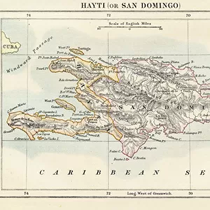
Map of Santo Domingo on Hispaniola Island in Dominican Republic

![]()
Wall Art and Photo Gifts from Universal Images Group (UIG)
Map of Santo Domingo on Hispaniola Island in Dominican Republic
Cartography, America, 16th-17th centuries. Map of Santo Domingo on Hispaniola Island
Universal Images Group (UIG) manages distribution for many leading specialist agencies worldwide
Media ID 9570329
© DEA / G. DAGLI ORTI
18th Century Cliff Coastline Direction Dominican Republic Elevated View Guidance Hill Horizon Horizon Over Land Human Settlement Nautical Vessel Navigational Equipment Old Fashioned Sailing Ship Santo Domingo Ship Text Town Transportation Western Script Antilles Islands Non Urban Scene
FEATURES IN THESE COLLECTIONS
> Architecture
> Country
> America
> Arts
> Art Movements
> Landscapes
> Arts
> Contemporary art
> Landscapes
> Sculptures
> Arts
> Contemporary art
> Sculpture
> Landscape paintings
> Arts
> Landscape paintings
> Landscape art
> Landscape paintings
> Arts
> Landscape paintings
> Landscape art
> Arts
> Street art graffiti
> Urban art
> Landscape paintings
> North America
> Dominican Republic
> Dominican Republic Heritage Sites
> Colonial City of Santo Domingo
> North America
> Dominican Republic
> Maps
> Universal Images Group (UIG)
> Art
> Painting, Sculpture & Prints
> Cartography
EDITORS COMMENTS
This print showcases a remarkable piece of cartography from the 16th-17th centuries, depicting the Map of Santo Domingo on Hispaniola Island in the Dominican Republic. The image transports us back in time to an era where art and craft merged with navigational expertise to create stunning maps like this one. The map itself is a testament to the rich history and cultural significance of Santo Domingo. It beautifully captures the town's architectural landscape, with its old-fashioned buildings perched atop hills overlooking the sea. A sailing ship gracefully glides across the horizon, symbolizing both transportation and exploration during that period. Every detail has been meticulously illustrated, from topographical features such as cliffs and coastlines to navigational equipment represented by Western script text. This comprehensive map served as a vital tool for guidance and travel in those times when technology was limited. As we gaze at this elevated view, it becomes evident that human settlement played a crucial role in shaping Santo Domingo's past. The absence of people allows us to focus solely on appreciating the intricate details of this historical artifact. Through this photo print, Universal Images Group (UIG) invites us to immerse ourselves in history while marveling at how far we have come since then. It serves as a reminder of our connection with the past and offers insight into how landscapes have evolved over time.
MADE IN THE USA
Safe Shipping with 30 Day Money Back Guarantee
FREE PERSONALISATION*
We are proud to offer a range of customisation features including Personalised Captions, Color Filters and Picture Zoom Tools
SECURE PAYMENTS
We happily accept a wide range of payment options so you can pay for the things you need in the way that is most convenient for you
* Options may vary by product and licensing agreement. Zoomed Pictures can be adjusted in the Cart.