Home > Animals > Mammals > Soricidae > Navigator
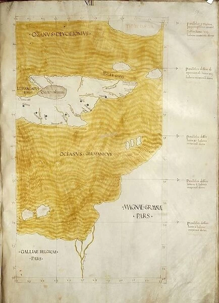
Map representing Thule Island, South Sandwich Islands, according to description of Greek navigator and cartographer Pytheas of Marseilles
![]()

Wall Art and Photo Gifts from Universal Images Group (UIG)
Map representing Thule Island, South Sandwich Islands, according to description of Greek navigator and cartographer Pytheas of Marseilles
Cartography. Map representing Thule Island (South Sandwich Islands), according to the description of Greek navigator and cartographer Pytheas of Marseilles (Massilia), lived in 4th century b.C
Universal Images Group (UIG) manages distribution for many leading specialist agencies worldwide
Media ID 9501997
© DEA PICTURE LIBRARY
4th Century Bc Geography Island Western Script Yellow South Sandwich Islands
FEATURES IN THESE COLLECTIONS
> Animals
> Mammals
> Soricidae
> Navigator
> South America
> South Georgia and South Sandwich
> Maps
> Universal Images Group (UIG)
> Art
> Painting, Sculpture & Prints
> Cartography
EDITORS COMMENTS
This print showcases a meticulously detailed map representing Thule Island, located in the South Sandwich Islands. The map is based on the description provided by Pytheas of Marseilles, an esteemed Greek navigator and cartographer who lived during the 4th century BC. With its vertical orientation and vibrant yellow hues, this illustration truly brings to life the island's geography and topography. The absence of people in this image allows us to focus solely on the intricate details of the map. Every contour and feature has been intricately depicted using Western script, highlighting Pytheas' remarkable knowledge and expertise in cartography. This artwork serves as a testament to his pioneering contributions to ancient navigation. As we delve into this historical masterpiece, it becomes evident that Thule Island holds great significance within our understanding of early exploration. Its representation provides valuable insights into how ancient civilizations perceived distant lands and expanded their geographical knowledge. This print from Universal Images Group (UIG) offers a unique glimpse into both history and artistry. It is not intended for commercial use but rather invites viewers to appreciate the beauty of cartographic craftsmanship while unraveling centuries-old mysteries surrounding Thule Island.
MADE IN THE USA
Safe Shipping with 30 Day Money Back Guarantee
FREE PERSONALISATION*
We are proud to offer a range of customisation features including Personalised Captions, Color Filters and Picture Zoom Tools
SECURE PAYMENTS
We happily accept a wide range of payment options so you can pay for the things you need in the way that is most convenient for you
* Options may vary by product and licensing agreement. Zoomed Pictures can be adjusted in the Cart.


