Home > Asia > Turkey > Istanbul
Photographic Print : Turkey / Byzantium
![]()

Photo Prints from Mary Evans Picture Library
Turkey / Byzantium
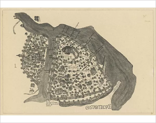
Florentine map of the imperial city of Byzantium, before the Turkish conquest of 1453, showing how the city is divided by the Golden Horn
Mary Evans Picture Library makes available wonderful images created for people to enjoy over the centuries
Media ID 592621
© Mary Evans Picture Library 2015 - https://copyrighthub.org/s0/hub1/creation/maryevans/MaryEvansPictureID/10041442
1453 Byzantium Conquest Divided Florentine Horn Istanbul
14"x11" Photo Print
Discover the rich history of Byzantium with our exquisite Media Storehouse Photographic Prints featuring this captivating Florentine map of the imperial city. Dating back to before the Turkish conquest in 1453, this rare and intriguing image showcases the division of Byzantium by the Golden Horn. Bring the intrigue and allure of ancient civilizations into your home or office with this stunning, high-quality print. Perfect for history enthusiasts, educators, or anyone seeking to add a touch of the past to their decor. Order now and transport yourself back in time.
Photo prints are produced on Kodak professional photo paper resulting in timeless and breath-taking prints which are also ideal for framing. The colors produced are rich and vivid, with accurate blacks and pristine whites, resulting in prints that are truly timeless and magnificent. Whether you're looking to display your prints in your home, office, or gallery, our range of photographic prints are sure to impress. Dimensions refers to the size of the paper in inches.
Our Photo Prints are in a large range of sizes and are printed on Archival Quality Paper for excellent colour reproduction and longevity. They are ideal for framing (our Framed Prints use these) at a reasonable cost. Alternatives include cheaper Poster Prints and higher quality Fine Art Paper, the choice of which is largely dependant on your budget.
Estimated Image Size (if not cropped) is 35.5cm x 24.5cm (14" x 9.6")
Estimated Product Size is 35.5cm x 27.9cm (14" x 11")
These are individually made so all sizes are approximate
Artwork printed orientated as per the preview above, with landscape (horizontal) orientation to match the source image.
FEATURES IN THESE COLLECTIONS
> Maps and Charts
> Early Maps
EDITORS COMMENTS
This print depicts a historical map of Byzantium, the imperial city that would later become Istanbul, as it appeared before the Turkish conquest of 1453. The map, created in the Florentine style, showcases the city's unique geographical feature, the Golden Horn. The Golden Horn, a natural harbor formed by a large inlet, divides the European and Asian parts of the city, making it a strategic location for trade and defense. Byzantium, also known as Constantinople, was the capital city of the Eastern Roman Empire for over a thousand years. Its rich history is evident in the intricate details of this map, which highlights the city's fortifications, major landmarks, and waterways. The map also reveals the political divisions within the empire, with different regions and territories indicated by distinct colors and symbols. The impending Turkish conquest, led by Sultan Mehmed II, is a significant historical event that marked the end of the Byzantine Empire and the beginning of the Ottoman Empire. This map offers a fascinating glimpse into the city's past, before the cultural and architectural transformations that would take place under Ottoman rule. The Golden Horn, with its protective crescent shape, played a crucial role in the defense of the city. The map illustrates the strategic importance of the harbor, which allowed the Byzantine fleet to control access to the Bosphorus and the Black Sea. The map also reveals the city's complex urban layout, with its labyrinthine streets, bustling markets, and grand palaces. This print is a valuable historical resource, providing insights into the political, cultural, and geographical landscape of Byzantium before its transformation into Istanbul. It is a testament to the rich history and enduring legacy of this iconic city, which continues to captivate visitors from around the world.
MADE IN THE USA
Safe Shipping with 30 Day Money Back Guarantee
FREE PERSONALISATION*
We are proud to offer a range of customisation features including Personalised Captions, Color Filters and Picture Zoom Tools
SECURE PAYMENTS
We happily accept a wide range of payment options so you can pay for the things you need in the way that is most convenient for you
* Options may vary by product and licensing agreement. Zoomed Pictures can be adjusted in the Cart.


