Home > Europe > United Kingdom > Scotland > Stirlingshire > Stirling
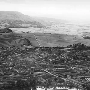
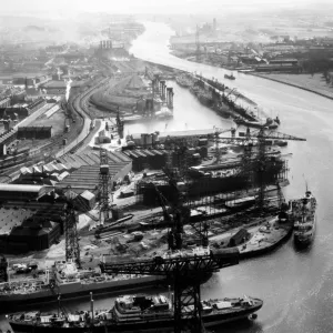
Stirling Rail Station, Stirling, 2010

![]()
Wall Art and Photo Gifts from RCAHMS
Stirling Rail Station, Stirling, 2010
Stirling, Stirling, STIRLINGSHIRE, SCOTLAND facing East. NCAP: RCAHMS Aerial Survey - 26/04/2010
Media ID 4056653
FEATURES IN THESE COLLECTIONS
> Aerial Photography
> Scotland
> Europe
> United Kingdom
> Scotland
> Dundee
> Dundee
> Europe
> United Kingdom
> Scotland
> Fife
> Related Images
> Europe
> United Kingdom
> Scotland
> Stirling
> Europe
> United Kingdom
> Scotland
> Stirlingshire
> Stirling
> Historic
> Monuments and landmarks
> Monuments and memorials
> Historic
> Monuments and landmarks
> Royal Commission on The Ancient And
> National Collection of Aerial
> Above Scotland Cities
> Royal Commission on The Ancient And
> Scotland by Area
> Central, Dundee and Fife
> Transportation
> Trains
EDITORS COMMENTS
This aerial photograph captures the essence of Stirling Rail Station in the year 2010. Located in the heart of Stirling, a historic city nestled amidst the picturesque landscapes of Stirlingshire, Scotland, this bustling transportation hub has long been an integral part of daily life for locals and visitors alike. The image showcases a panoramic view facing eastward, allowing us to marvel at the intricate details that make up this significant architectural landmark. The station's design seamlessly blends modernity with elements reminiscent of its rich historical past. From above, we can see how it effortlessly connects various parts of the city through its well-planned railway network. Notably, construction activity is visible within this snapshot, highlighting ongoing efforts to enhance and expand upon this vital transport infrastructure. The presence of trains on multiple tracks signifies the constant movement and connectivity that define Stirling Rail Station as a vibrant center for travel and commerce. Burghmuir Road gracefully winds its way around the station area, serving as a gateway to further exploration beyond these rail lines. This road symbolizes both access and opportunity for those embarking on journeys from or arriving at this dynamic locale. Preserved by NCAP: RCAHMS Aerial Survey on April 26th, 2010, this print serves as a testament to our fascination with capturing moments frozen in time. It allows us to appreciate not only the physical beauty but also acknowledges how crucial such landmarks are in shaping communities throughout history – reminding us that they are more than just structures
MADE IN THE USA
Safe Shipping with 30 Day Money Back Guarantee
FREE PERSONALISATION*
We are proud to offer a range of customisation features including Personalised Captions, Color Filters and Picture Zoom Tools
SECURE PAYMENTS
We happily accept a wide range of payment options so you can pay for the things you need in the way that is most convenient for you
* Options may vary by product and licensing agreement. Zoomed Pictures can be adjusted in the Cart.