Home > Europe > Sweden > Maps
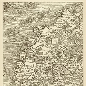
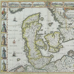
Jigsaw Puzzle : Siege of Copenhagen 1659


![]()
Jigsaw Puzzles from Mary Evans Picture Library
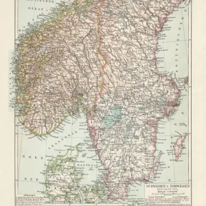
Siege of Copenhagen 1659
Map of the siege of Copenhagen, Denmark by Carl X Gustav of Sweden
Mary Evans Picture Library makes available wonderful images created for people to enjoy over the centuries
Media ID 604723
© Mary Evans Picture Library 2015 - https://copyrighthub.org/s0/hub1/creation/maryevans/MaryEvansPictureID/10050867
1659 Carl Copenhagen Denmark Gustav Scandinavia Siege Sweden
Jigsaw Puzzle (252 Pieces)
Discover the thrilling history of the Siege of Copenhagen in 1659 with Media Storehouse's captivating jigsaw puzzle. This intricately detailed puzzle features an authentic map of the siege, as depicted in the Mary Evans Picture Library from Mary Evans Prints Online. Originally drawn by Carl X Gustav of Sweden, this historical map brings to life the strategic battle for control of Copenhagen, Denmark. Immerse yourself in the rich history of this pivotal moment in European history as you piece together the intricate details of this stunning puzzle. Perfect for history enthusiasts, puzzle aficionados, or anyone seeking a challenging and rewarding pastime, Media Storehouse's Siege of Copenhagen 1659 jigsaw puzzle is a must-have addition to your collection.
Made in the USA, 252-piece puzzles measure 11" x 14" (27.9 x 35.5 cm). Every puzzle is meticulously printed on glossy photo paper, which has a strong 1.33 mm thickness. Delivered in a black storage cardboard box, these puzzles are both stylish and practical. (Note: puzzles contain small parts and are not suitable for children under 3 years of age.)
Jigsaw Puzzles are an ideal gift for any occasion
Estimated Product Size is 35.6cm x 28cm (14" x 11")
These are individually made so all sizes are approximate
Artwork printed orientated as per the preview above, with landscape (horizontal) orientation to match the source image.
FEATURES IN THESE COLLECTIONS
> Europe
> Denmark
> Copenhagen
> Europe
> Denmark
> Related Images
> Europe
> Sweden
> Related Images
> Maps and Charts
> Early Maps
EDITORS COMMENTS
This stunning print captures the historical Siege of Copenhagen in 1659, a pivotal event during the reign of Carl X Gustav of Sweden. The detailed map showcases the strategic maneuvers and military tactics employed by Swedish forces as they laid siege to the city of Copenhagen, Denmark in February of that year.
The intricate details on this print provide a fascinating glimpse into one of Scandinavia's most significant historical events. From the positioning of troops to the layout of fortifications, every aspect of this siege is meticulously documented for viewers to explore.
As we study this image, we are transported back in time to witness firsthand the intensity and drama that unfolded during those fateful days in 1659. The clash between Sweden and Denmark comes alive through this vivid depiction, offering us a deeper understanding of the political tensions and military conflicts that shaped European history during this period.
Whether you are a history enthusiast or simply appreciate fine artistry, this print from Mary Evans Picture Library is sure to captivate your imagination and spark your curiosity about one of Europe's most intriguing chapters. Dive into the past with this compelling visual representation of the Siege of Copenhagen - an unforgettable moment in time captured for all to admire.
MADE IN THE USA
Safe Shipping with 30 Day Money Back Guarantee
FREE PERSONALISATION*
We are proud to offer a range of customisation features including Personalised Captions, Color Filters and Picture Zoom Tools
SECURE PAYMENTS
We happily accept a wide range of payment options so you can pay for the things you need in the way that is most convenient for you
* Options may vary by product and licensing agreement. Zoomed Pictures can be adjusted in the Cart.