Home > Europe > United Kingdom > England > South Yorkshire > Sheffield
y15494

![]()
Wall Art and Photo Gifts from Sheffield City Archives
y15494
Sheffield City Archives and Local Studies Library has an unrivalled collection of images of Sheffield, England
Media ID 35983561
© Sheffield City Council - All Rights Reserved
FEATURES IN THESE COLLECTIONS
> Arts
> Artists
> P
> those present
> Europe
> United Kingdom
> England
> Maps
> Europe
> United Kingdom
> England
> Rivers
> Europe
> United Kingdom
> England
> Sheffield
> Europe
> United Kingdom
> England
> South Yorkshire
> Sheffield
> Europe
> United Kingdom
> England
> Yorkshire
> Sheffield
> Europe
> United Kingdom
> England
> Yorkshire
> Street
> Historic
> Monuments and landmarks
> Maps and Charts
> Early Maps
VISUAL DESCRIPTION
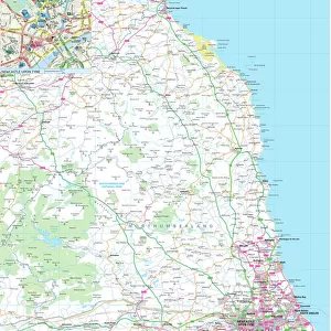
This is an antique map titled "Bacon's Plan of Sheffield," showcasing the layout of Sheffield, a city in South Yorkshire, England. The map is intricately detailed, displaying streets, buildings, and notable landmarks with precision indicative of the cartographic style from the late 19th to early 20th century. It features a color scheme that differentiates various districts or zones within the city and includes natural geographic features such as rivers (most likely including the River Don which flows through Sheffield). A compass rose is present indicating cardinal directions. The labeling on the map suggests it was intended for practical use to navigate or understand urban development at that time.
MADE IN THE USA
Safe Shipping with 30 Day Money Back Guarantee
FREE PERSONALISATION*
We are proud to offer a range of customisation features including Personalised Captions, Color Filters and Picture Zoom Tools
SECURE PAYMENTS
We happily accept a wide range of payment options so you can pay for the things you need in the way that is most convenient for you
* Options may vary by product and licensing agreement. Zoomed Pictures can be adjusted in the Cart.