Home > Abstract Art > Rainbows
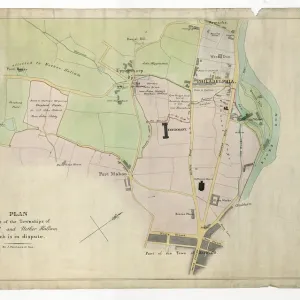
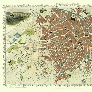
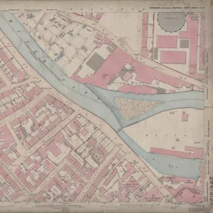
Ordnance Survey Map, West Bar area, Sheffield, 1889 (Yorkshire sheet 294. 8. 11)
")
![]()
Wall Art and Photo Gifts from Sheffield City Archives
Ordnance Survey Map, West Bar area, Sheffield, 1889 (Yorkshire sheet 294. 8. 11)
This map features:
Top left: West Bar, tramway, Corporation Street, West Bar Green, Moseley's Arms Public House, Scotland Street, Crown Inn, Lambert Street, Steelhouse Lane, Furnace Hill, Copper Street, Trinity Street, Albion Yard, [F G Pearson and Co.], Hope Works (steel edge tools, augers, files, etc) on Furnace Hill, Gaiety Music Hall on Steelhouse Lane / Corporation Street, Gaiety Public House, George and Dragon Public House, Hallamshire Hall at West Bar Green, cabmen's shelter, cab stand, urinal and posts, New Row, Lambert Place, Birmingham Arms Public House, [R. Rodgers and Son], Norfolk Works (cutlery) on Lambert Street, London House Public House, [George Gill], Norbury Works (scissors) on Lambert Street, Smithy, Grapes Inn, [Scotland Street] Methodist Chapel (New Connexion) in margin, Sun Inn, Corporation Depot No. 1.
Top right: tramway, Corporation Street, Spring Street, Water Street, Love Street, Bridge Street, Mill Walk, Love Lane, Newhall Street, Coulson Street, Hicks Lane, Workhouse Lane, North Church Street, Snig Hill, New Street, Blue Boar public House, Oxford Public House, Sheffield Union Offices and Vestry Hall, Ball Public House, [Henry Dixon, Manufacturing Confectioner?], Britannia Works (British Plate) on Love Street, [George H. Taylor and Brother], Times Works (cutlery) on Love Street / Water Street, Love Street, [W. T. Flather], Love Street Steel Works (in margin), [William Machell and Co. / Dodworth Brothers], Bridge Street Works (edge tool and cutlery), Surrey Hotel, timber shed, Central Engineering Works and Iron Foundry, [Charles Neill], Campbell Works (steel) on Bridge Street, Punch Bowl Public House, Town Mills (corn), [J. T. Dobb and Son], Spring Street Works (paint and varnish), Grand Concert Hall Public House, Nottingham Hotel Public House, Public Offices, Pack Horse Inn, Three Travellers Inn, Tramway Hotel Public House, [Sheffield Bottling Co. Ltd.], Crystal Mineral Water Works (on Spring Street), Cross Love Street, Post Office on West Bar, White Swan Inn, Hollis Hospital and School.
Bottom left: West Bar Green, Moseley's Arms Public House, Scotland Street, Queen Street, Crown Inn, Tenter Street, Grindlegate, Pea Croft, White Croft, Hawley Croft, Sims Croft, Hawley Lane, Silver Street Head, Paradise Square, Lee Croft, Silver Street, Paradise Lane, [St. William's Roman Catholic] School (on Hawley Croft), Queen's Foundry (iron), Paradise Street, Queen's Street Hotel Public House, St. Peter's School, playground, [John Hall and Co.], Printing Works off Paradise Square, Wostenholm [Memorial] Hall on Queen Street, Three Tuns Inn, Shrewsbury Hotel Public House, Eagle Tavern, Bay Horse Inn, White Lion Hotel Public House, Standard Hotel Public House, St. William's R.C. Church, [St Williams Roman Catholic] School (Boys and Girls), Rawson's Hotel Public House, [Wingfield, Rowbotham and Co.], Cutlery Works on Tenter Street, Police Station on Tenter Street, Ball Inn, Cross Daggers Public House.
Bottom right: Paradise Street, North Church Street, Snig Hill, New Street, Scargill Croft, Bank Street, Queen Street, Wheats Lane, St. Peter's Close, Figtree Lane, Harts Head, Meetinghouse Lane, Friends Meetinghouse, Watson's Walk, Campo Lane, Ball Public House, Health Office, Jews Synagogue [Jewish synagogue] on North Church Street, Printing Works on St Peter's Close, East Parade Hotel Public House, Hartshead Chambers on Hartshead, Town Clerk's Office on Hartshead, Hoole's Chamber on Queen Street, Victoria Chambers on Figtree Lane, County Court Hall on Bank Street / New Street, Queen Street Chambers, Murray's Arms Public House, Queen's Street Chapel (Independent), Sunday school, Three Cranes Inn, Wharncliffe Chambers on Scargill Croft, Independent Printing Works off Scargill Croft, Black Lion Public House, Black Swan Public House, George and Dragon Public House, Bank, unidentified school [entered via Meetinghouse Lane or Hartshead Square / Watsons Walk?], Dove and Rainbow Public House, Police Institute, Victoria Club (in margin), Charity School (boys) (in margin), Graveyard (in margin), Shades Vault Public House, Angel Inn.
Surveyed 1889. Reprint 75/98'.
Dimensions 77 x 102 cm.
Scale 10.56 feet : 1 mile [1:500].
From an original at Sheffield Libraries: q00080
Sheffield City Archives and Local Studies Library has an unrivalled collection of images of Sheffield, England
Media ID 32416611
© Sheffield City Council - All Rights Reserved
Old Map Ordnance Survey Os Map Sheffield
FEATURES IN THESE COLLECTIONS
> Abstract Art
> Rainbows
> Animals
> Birds
> Accipitriformes
> Accipitridae
> Black Eagle
> Animals
> Birds
> Columbiformes
> Doves
> Black Dove
> Animals
> Birds
> Gruiformes
> Cranes
> Blue Crane
> Animals
> Birds
> Waterfowl
> Swans
> Black Swan
> Animals
> Farm
> Horses
> Paint Horse
> Animals
> Insects
> Hemiptera
> Black Scale
> Animals
> Insects
> Hemiptera
> Grape Scale
> Animals
> Insects
> Hemiptera
> Green Scale
> Animals
> Insects
> Hemiptera
> Hall Scale
> Sheffield City Archives
> Maps and Plans
> Sheffield OS maps
EDITORS COMMENTS
This print showcases an Ordnance Survey Map of the West Bar area in Sheffield, dating back to 1889. The map, labeled as Yorkshire sheet 294.8.11, provides a detailed depiction of the region during that time. The top left section of the map highlights various landmarks and establishments such as West Bar, tramway lines, Corporation Street, Moseley's Arms Public House, Scotland Street, Crown Inn, and many more. Notable features include Hope Works on Furnace Hill and Gaiety Music Hall on Steelhouse Lane/Corporation Street. Moving to the top right section of the map reveals additional streets like Spring Street, Water Street, Love Street, Bridge Street, Mill Walks along with several public houses including Blue Boar and Oxford Public House. Industrial works like Britannia Works and Times Works are also marked in this area. The bottom left portion focuses on West Bar Green with its surrounding attractions such as Queen's Foundry (iron), St. William's Roman Catholic School on Hawley Croft and Wostenholm Memorial Hall on Queen Street. Lastly, the bottom right corner covers Paradise Street leading towards North Church street featuring notable locations like Jews Synagogue (Jewish synagogue) on North Church street and Victoria Chambers on Figtree Lane. This reprint offers a glimpse into Sheffield's past with dimensions measuring 77 x 102 cm at a scale of 10.56 feet:1 mile [1:500]. It is sourced from an original document housed at Sheffield Libraries under reference q00080).
MADE IN THE USA
Safe Shipping with 30 Day Money Back Guarantee
FREE PERSONALISATION*
We are proud to offer a range of customisation features including Personalised Captions, Color Filters and Picture Zoom Tools
SECURE PAYMENTS
We happily accept a wide range of payment options so you can pay for the things you need in the way that is most convenient for you
* Options may vary by product and licensing agreement. Zoomed Pictures can be adjusted in the Cart.