Home > Arts > Artists > B > Emanuel Bowen
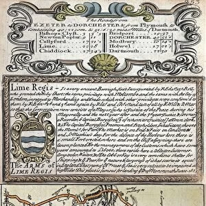
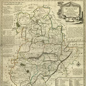
County Map of Suffolk, c. 1777

![]()
Wall Art and Photo Gifts from Sheffield City Archives
County Map of Suffolk, c. 1777
From The Large English Atlas: or, a new set of map of all the counties of England and Wales drawn from the several surveys which have been hitherto been published. With three general maps of England, Scotland and Ireland, from the latest and best authorities, by Emanuel Bowen, Thomas Kitchin and others. London, printed and sold by T. Bowles, [c.1777]
Original at Sheffield Libraries: 912 STF
Sheffield City Archives and Local Studies Library has an unrivalled collection of images of Sheffield, England
Media ID 25501501
© Sheffield City Council - All Rights Reserved
Antique Map Bowens Map County Map Emanuel Bowen Old Map Thomas Kitchin Beccles Brandon Bury St Edmunds Felixstowe Hadleigh Haverhill Ipswich Lowestoft Mildenhall Newmarket Stowmarket Sudbury Woodbridge
FEATURES IN THESE COLLECTIONS
> Arts
> Artists
> B
> Emanuel Bowen
> Arts
> Artists
> K
> Thomas Kitchin
> Europe
> Republic of Ireland
> Maps
> Europe
> United Kingdom
> England
> London
> Related Images
> Europe
> United Kingdom
> England
> Maps
> Europe
> United Kingdom
> England
> Sheffield
> Europe
> United Kingdom
> England
> Suffolk
> Beccles
> Europe
> United Kingdom
> England
> Suffolk
> Brandon
> Europe
> United Kingdom
> England
> Suffolk
> Bury St Edmunds
> Europe
> United Kingdom
> England
> Suffolk
> Felixstowe
> Sheffield City Archives
> Maps and Plans
> Bowen's County Maps, c. 1777
EDITORS COMMENTS
This print showcases the "County Map of Suffolk" dating back to around 1777. The map is a remarkable piece from "The Large English Atlas: or, a new set of maps of all the counties of England and Wales" meticulously drawn by renowned cartographers Emanuel Bowen, Thomas Kitchin, and others. With its intricate details and exquisite craftsmanship, this antique map offers a glimpse into the historical geography of Suffolk during that era. From bustling towns like Ipswich, Lowestoft, Bury St Edmunds, Haverhill, Felixstowe, Sudbury, Newmarket to smaller settlements such as Stowmarket, Kesgrave, Beccles; every corner is carefully depicted. As you explore this vintage treasure further with your eyes tracing over rivers and roads alike - Mildenhall's charm unfolds along with Woodbridge's coastal allure. Brandon's quaintness beckons while Hadleigh whispers tales from centuries past. This rare artifact provides an opportunity to immerse oneself in Suffolk's rich heritage and discover how landscapes have evolved over time. It serves as a testament to the skillful artistry employed by these esteemed cartographers who sought to capture the essence of each county they mapped. Preserved at Sheffield Libraries within their archives collection (912 STF), this old map stands as a testament to our collective history. Let it transport you back in time and ignite your curiosity about the people who once called these lands home – an invaluable window into Suffolk's past for generations present and future
MADE IN THE USA
Safe Shipping with 30 Day Money Back Guarantee
FREE PERSONALISATION*
We are proud to offer a range of customisation features including Personalised Captions, Color Filters and Picture Zoom Tools
SECURE PAYMENTS
We happily accept a wide range of payment options so you can pay for the things you need in the way that is most convenient for you
* Options may vary by product and licensing agreement. Zoomed Pictures can be adjusted in the Cart.