Home > Arts > Artists > B > Emanuel Bowen
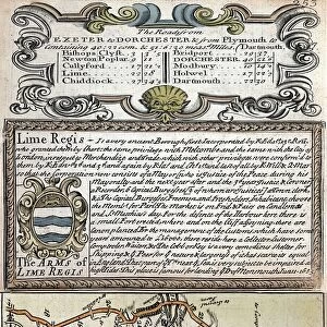
County Map of Pembrokeshire, Wales, c. 1777

![]()
Wall Art and Photo Gifts from Sheffield City Archives
County Map of Pembrokeshire, Wales, c. 1777
From The Large English Atlas: or, a new set of map of all the counties of England and Wales drawn from the several surveys which have been hitherto been published. With three general maps of England, Scotland and Ireland, from the latest and best authorities, by Emanuel Bowen, Thomas Kitchin and others. London, printed and sold by T. Bowles, [c.1777]
Original at Sheffield Libraries: 912 STF
Sheffield City Archives and Local Studies Library has an unrivalled collection of images of Sheffield, England
Media ID 25501479
© Sheffield City Council - All Rights Reserved
Antique Map Bowens Map County Map Emanuel Bowen Old Map Thomas Kitchin Fishguard Haverfordwest Milford Haven Newport Neyland Pembroke Saundersfoot St Davids Tenby
FEATURES IN THESE COLLECTIONS
> Arts
> Artists
> B
> Emanuel Bowen
> Arts
> Artists
> K
> Thomas Kitchin
> Europe
> Republic of Ireland
> Maps
> Europe
> United Kingdom
> England
> London
> Related Images
> Europe
> United Kingdom
> England
> Maps
> Europe
> United Kingdom
> England
> Sheffield
> Europe
> United Kingdom
> Scotland
> Maps
> Europe
> United Kingdom
> Wales
> Gwent
> Newport
> Europe
> United Kingdom
> Wales
> Maps
> Europe
> United Kingdom
> Wales
> Newport
> Sheffield City Archives
> Maps and Plans
> Bowen's County Maps, c. 1777
> Sheffield City Archives
> Maps and Plans
> Maps of Wales
EDITORS COMMENTS
This print showcases a County Map of Pembrokeshire, Wales, dating back to approximately 1777. A true gem from "The Large English Atlas: or, a new set of maps of all the counties of England and Wales" this antique map offers a glimpse into the rich history and geographical features of the region. Created by renowned cartographers Emanuel Bowen, Thomas Kitchin, and others in London, this masterpiece was printed and sold by T. Bowles. With intricate details and precision, the map highlights prominent towns such as Haverfordwest, Pembroke, Milford Haven, Fishguard, Tenby, Narberth, Neyland, Newport St Davids, and Saundersfoot. Each town is marked with its own unique charm on this vintage piece. As you explore this remarkable artifact from Sheffield Libraries' collection (912 STF), you'll be transported back in time to an era when maps were meticulously hand-drawn works of art. The delicate lines depict rivers winding through lush landscapes while mountains majestically rise in the distance. Whether you're a history enthusiast or simply appreciate the beauty found within old maps like these ones created by Emanuel Bowen and Thomas Kitchin - two esteemed figures in cartography - this print will undoubtedly captivate your imagination. Let it transport you to Pembrokeshire's past as you uncover hidden stories embedded within its ancient streets and picturesque countryside.
MADE IN THE USA
Safe Shipping with 30 Day Money Back Guarantee
FREE PERSONALISATION*
We are proud to offer a range of customisation features including Personalised Captions, Color Filters and Picture Zoom Tools
SECURE PAYMENTS
We happily accept a wide range of payment options so you can pay for the things you need in the way that is most convenient for you
* Options may vary by product and licensing agreement. Zoomed Pictures can be adjusted in the Cart.