Fraud Blocker Skip to main content

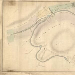
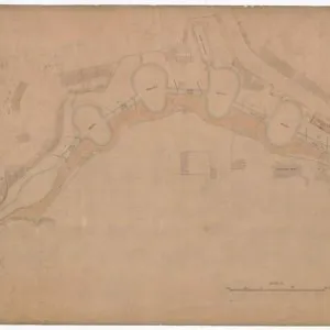
A Map of the Monkland Canal Drawn by Hugh Pate

A Map of the Monkland Canal Drawn by Hugh Pate
In Stock
We accept all major payment options so you can pay for the things you need in the way that is most convenient for you
Framed Photos
Buy from $79.99
Photo Prints
Buy from $13.99
Jigsaw Puzzles
Buy from $39.99
Poster Prints
Buy from $24.99
Canvas Prints
Buy from $159.99
Fine Art Prints
Buy from $88.90
Home Decor
Buy from $16.99

Scottish Canals Photo Prints and Wall Art

A Map of the Monkland Canal Drawn by Hugh Pate

A map of the route of the Monkland Canal showing the locations, and listing the names of, houses and bridges adjacent to the canal. Scottish Canals are in charge of the five canals in Scotland. © Scottish Canals

Media ID 14482733

SECURE PAYMENTS
We accept all major payment options so you can pay for the things you need in the way that is most convenient for you

Made in USA
Safe Shipping, Easy Returns

FREE PERSONALISATION
We are proud to offer a range of customisation including Cropping, Captions, and Filters. Zoom Cropping can be adjusted in the basket


EDITORS COMMENTS

This print showcases a historical gem, "A Map of the Monkland Canal Drawn by Hugh Pate" meticulously crafted by Ramsay K. This intricate map provides an invaluable glimpse into the past, revealing the route of the Monkland Canal and its surrounding landmarks. As we delve into this visual treasure trove, we are transported back in time to witness the thriving canal network that once connected bustling communities. With utmost precision, Hugh Pate's skilled hand has traced every twist and turn of this vital waterway. The map not only highlights the canal's path but also offers a fascinating insight into adjacent houses and bridges that dotted its banks. Each location is thoughtfully listed, allowing us to envision life along these historic shores. As we explore this remarkable piece of cartography from Scottish Canals' collection, our imagination runs wild with tales of barges gliding through tranquil waters while locals bustled about their daily lives nearby. We can almost hear echoes of laughter and conversations carried on gentle breezes as people went about their business in harmony with nature. Ramsay K. 's expertly captured photograph ensures that future generations can appreciate this extraordinary historical artifact for years to come. It serves as a poignant reminder of Scotland's rich industrial heritage and pays homage to those who built and maintained these vital lifelines throughout history. In preserving such treasures like "A Map of the Monkland Canal Drawn by Hugh Pate". Scottish Canals continues to honor our past while inspiring curiosity in all who gaze.


Framed Prints of A Map of the Monkland Canal Drawn by Hugh Pate

Discover the rich history of Scotland's waterways with our stunning Framed Print of A Map of the Monkland Canal Drawn by Hugh Pate by Ramsay, K. from Scottish Canals. This intricately detailed map showcases the historic route of the Monkland Canal, featuring the names and locations of houses and bridges that once lined its shores. A beautiful addition to any home office, study, or living space, this framed print is not only a decorative piece but also a fascinating glimpse into Scotland's industrial past. Bring a piece of Scottish history into your home and transport yourself on a journey along the Monkland Canal with every glance. Order yours today!


Photo Prints of A Map of the Monkland Canal Drawn by Hugh Pate

Step back in time with our exquisite photographic print of "A Map of the Monkland Canal Drawn by Hugh Pate" by Ramsay, K. from Scottish Canals. This captivating print showcases an intricately detailed map of the historic Monkland Canal, meticulously drawn by Hugh Pate and beautifully captured by Ramsay, K. Each house and bridge adjacent to the canal is clearly labeled, providing a fascinating glimpse into Scotland's industrial past. Add this timeless piece to your walls and bring a piece of history into your home or office.


Poster Prints of A Map of the Monkland Canal Drawn by Hugh Pate

Discover the rich history of Scotland's waterways with our stunning poster prints from Media Storehouse. This particular design showcases a captivating map of the Monkland Canal, drawn by K. Ramsay from Scottish Canals. The intricately detailed illustration brings to life the route of the canal, complete with the names and locations of houses and bridges. A perfect addition to any home office, study, or living space, this poster print is not only an attractive piece of art but also an educational and inspiring reminder of Scotland's industrial heritage. Immerse yourself in the story of the Monkland Canal and add a touch of history to your decor with this beautiful poster print.


Jigsaw Puzzles of A Map of the Monkland Canal Drawn by Hugh Pate

Discover the rich history of Scotland's waterways with Media Storehouse's Jigsaw Puzzle featuring a captivating map of the Monkland Canal. Drawn by K. Ramsay from Scottish Canals, this intricately detailed puzzle showcases the historic route of the canal, complete with the names and locations of houses and bridges. Immerse yourself in the past as you piece together this beautiful jigsaw puzzle, a perfect activity for puzzle enthusiasts and history buffs alike. Bring the tranquility of the Monkland Canal into your home and enjoy the satisfaction of completing this engaging and educational puzzle.

diamond
Made With High Grade Materials
thumb_up
Professional Quality Finish
package_2
Carefully Packed To Aid Safe Arrival

You May Also Like


Plan of the Monkland Canal from Coats Lands to the Termination at Wood Hall BridgePlan of the Monkland Canal from Coats Lands to the Termination at Wood Hall Bridge
Add to Basket
Plan of the Caledonian Canal and lands belonging thereto Part VPlan of the Caledonian Canal and lands belonging thereto Part V
Add to Basket
Skyline Of Downtown Edmonton Reflected In The North Saskatchewan River Under A Blue Sky; Edmonton, Alberta, CanadaSkyline Of Downtown Edmonton Reflected In The North Saskatchewan River Under A Blue Sky; Edmonton, Alberta, Canada
Add to Basket
English tourists see Scots dancing to bagpipe musicEnglish tourists see Scots dancing to bagpipe music
Add to Basket
Standing Female Nude, c. 1855 (albumen print, mounted)Standing Female Nude, c. 1855 (albumen print, mounted)
Add to Basket
View of the town of Porto Cristo, Majorca, SpainView of the town of Porto Cristo, Majorca, Spain
Add to Basket
3058823630588236
Add to Basket
Old Map of the Mining Village of Hednesford in Staffordshire 1865Old Map of the Mining Village of Hednesford in Staffordshire 1865
Add to Basket
EX 2007 DSC 0187EX 2007 DSC 0187
Add to Basket
Johnny Rea (Yamaha) 1991 Supersport 600 TTJohnny Rea (Yamaha) 1991 Supersport 600 TT
Add to Basket
Surfers on the beach, Perranporth, Perranzabuloe, Cornwall. Probably June 1922Surfers on the beach, Perranporth, Perranzabuloe, Cornwall. Probably June 1922
Add to Basket
At Last the 1948 Show, starring John Cleese, Aimee McDonald, Graham Chapman, Tim Brooke-Taylor and Marty FeldmanAt Last the 1948 Show, starring John Cleese, Aimee McDonald, Graham Chapman, Tim Brooke-Taylor and Marty Feldman
Add to Basket

Gallery Wall Inspiration

SC0150reduced
Rules & Regulations for the Conduct of Masters of Vessels and Other Persons Resorting to and Using the Caledonian Canal and the Harbours, Basins, Wharfs, Locks etc. Thereto Belonging
Canal Basin Area. The Corporation of Edinburgh and The North British Railway Company. Plan Referred to in Agreement
SC0362Breduced
ScottishCanals
Map or Chart of the Caledonian Canal, or Inland Navigation from the Western to the Eastern Sea by Fort William and Inverness
Plan of the Crinan Canal from the March of Dunadry on the South to Port Ree on the North No. III
Plan of the Crinan Canal from the March of Oakfield on the South to the March of Blarindibbart on the North Plan No. II
Plan of Ardrishaig Harbour
Plan of the Crinan Canal through the Estate of Oakfield Plan No. I
SC0503reduced
Plan of the Caledonian Canal and lands belonging thereto Part I
Plan of the Caledonian Canal and lands belonging thereto Part V
Plan of the Caledonian Canal and lands belonging thereto Part IV
SC0556reduced
SC0128reduced
Plan of Gound Feued by the Forth and Clyde Canal Company from the Earl of Zetland
A Map of the Monkland Canal Drawn by Hugh Pate
Plan of the Monkland Canal from Coats Lands to the Termination at Wood Hall Bridge
Plan of the boundary line between the Inchbelly Road and Stirlings Road from the junction of said roads at the Townhead of Glasgow opposite St Mungos burying ground to Garngad Hill Road
County of Linlithgow Bathgate District Bridge at Broxburn over the Union Canal Drawing No. 2
Plan of the Caledonian Canal and lands belonging thereto Part II
Plan of the Caledonian Canal and lands belonging thereto Part III
Plan of the Caledonian Canal and lands belonging thereto Part VI
Plan of the Caledonian Canal betwixt Clachnacharry and Lochness with the Adjacent Country
Monkland Canal. Details of the Machinery of the Proposed Inclined Plane at Blackhill
Turnpike Road Bridge


© Copyright Media Storehouse, All Rights Reserved 2003 - 2024
Facebook     Pinterest     100% Payment Secure     Reviews IO