Home > Maps and Charts > Early Maps
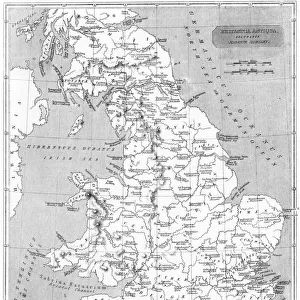
Roman Stations Map

Wall Art and Photo Gifts from Mary Evans Picture Library
Roman Stations Map
A map depicting the network of Roman settlements in Britain
Mary Evans Picture Library makes available wonderful images created for people to enjoy over the centuries
Media ID 609913
© Mary Evans Picture Library 2015 - https://copyrighthub.org/s0/hub1/creation/maryevans/MaryEvansPictureID/10117078
Depicting Maps Net Work Settlements Stations
EDITORS COMMENTS
This stunning print showcases a detailed Roman Stations Map, depicting the extensive network of Roman settlements in Britain. The intricate design and historical significance of this map provide a fascinating glimpse into the ancient world and the vast empire that once ruled over these lands.
Dating back to circa ancient times, this map offers a unique perspective on how the Romans established their presence in Britain through a series of strategically placed stations and settlements. Each point on the map tells a story of conquest, trade, and cultural exchange that shaped the landscape of Britain during this period.
The craftsmanship and attention to detail in this print are truly remarkable, capturing the essence of Roman engineering and urban planning. From bustling cities to remote outposts, every corner of Britain is meticulously documented on this map, offering viewers a glimpse into the past like never before.
Whether you're a history buff or simply appreciate fine artistry, this Roman Stations Map is sure to captivate your imagination and transport you back in time to an era when emperors reigned supreme and legions marched across distant lands. Add this piece from Mary Evans Picture Library to your collection today and bring a piece of ancient history into your home.
MADE IN THE USA
Safe Shipping with 30 Day Money Back Guarantee
FREE PERSONALISATION*
We are proud to offer a range of customisation features including Personalised Captions, Color Filters and Picture Zoom Tools
SECURE PAYMENTS
We happily accept a wide range of payment options so you can pay for the things you need in the way that is most convenient for you
* Options may vary by product and licensing agreement. Zoomed Pictures can be adjusted in the Cart.