Home > Maps and Charts > Cyprus
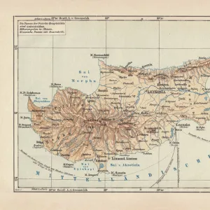
Ottoman map of Cyprus

![]()
Wall Art and Photo Gifts from Mary Evans Picture Library
Ottoman map of Cyprus
Mary Evans Picture Library makes available wonderful images created for people to enjoy over the centuries
Media ID 4452049
© Mary Evans Picture Library 2015 - https://copyrighthub.org/s0/hub1/creation/maryevans/MaryEvansPictureID/10411669
FEATURES IN THESE COLLECTIONS
> Asia
> Cyprus
> Related Images
> Maps and Charts
> Early Maps
EDITORS COMMENTS
1. Title: "The Ottoman Map of Cyprus: A Testament to Historical Complexities". This exquisite Ottoman map of Cyprus, dating back to the late 16th or early 17th century, offers a captivating glimpse into the rich historical tapestry of the island and its complex political landscape during the Ottoman Empire. The intricately detailed map, adorned with vibrant colors and calligraphy, reveals the extensive knowledge and cartographic prowess of the Ottoman Empire at its zenith. Cyprus, an island located in the eastern Mediterranean, has been a coveted prize for various empires throughout history. The Ottomans, who ruled the island from 1571 to 1878, left an indelible mark on its cultural and historical fabric. This map, a testament to their presence, showcases the Ottoman administrative divisions, fortifications, and settlements, providing valuable insights into the island's geography and demographics during that period. The Ottoman map of Cyprus also underscores the complexities of the Ottoman Empire, which was not a monolithic entity but a diverse and multicultural empire that embraced various religious and ethnic groups. The map reflects this diversity, with place names in Arabic, Greek, and Latin scripts, indicating the coexistence of different communities on the island. Moreover, the map offers a snapshot of the Ottoman approach to governance, which relied on a decentralized system that granted a degree of autonomy to local rulers and communities. The presence of numerous fortifications and garrisons on the map underscores the importance of maintaining order and security in the far-flung provinces of the empire. In conclusion, this Ottoman map of Cyprus is not just a historical artifact but a window into the past that sheds light on the political, cultural, and administrative complexities of the Ottoman Empire. Its intricate details and rich symbolism continue to fascinate scholars, historians, and enthusiasts of cartography and Ottoman history.
MADE IN THE USA
Safe Shipping with 30 Day Money Back Guarantee
FREE PERSONALISATION*
We are proud to offer a range of customisation features including Personalised Captions, Color Filters and Picture Zoom Tools
SECURE PAYMENTS
We happily accept a wide range of payment options so you can pay for the things you need in the way that is most convenient for you
* Options may vary by product and licensing agreement. Zoomed Pictures can be adjusted in the Cart.