
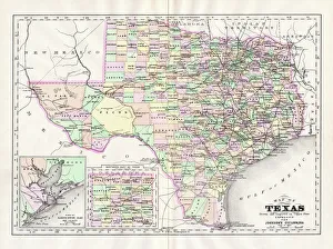
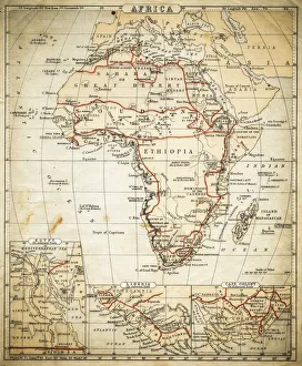
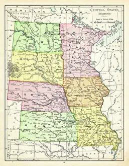
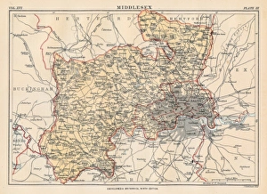
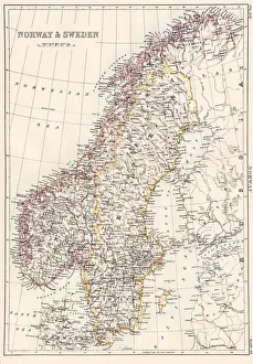
Maps Jigsaw Puzzle Collection (#2)
Discover the vibrant energy of New York City with our Maps of New York jigsaw puzzles from Media Storehouse. Each intricately designed puzzle features detailed representations of iconic landmarks, bustling streets, and scenic parks. Immerse yourself in the beauty and complexity of these 1000-piece puzzles, perfect for puzzle enthusiasts and armchair travelers alike. Explore the heart of North America's most populous city and create a cherished keepsake to display in your home.
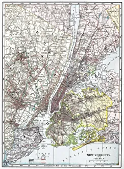
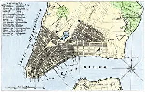
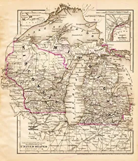
New York City is one of the most iconic cities in the world, and its they can a reflection of this
1,413 Jigsaw Puzzles


All Professionally Made to Order for Quick Shipping
-
Maps Jigsaw Puzzle Collection
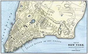
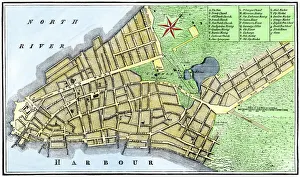
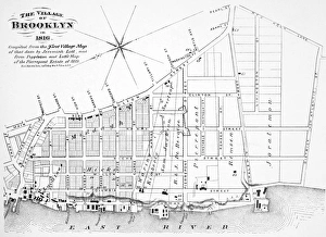
New York City is one of the most iconic cities in the world, and its they can a reflection of this. Maps of New York show the five boroughs: Manhattan, Brooklyn, Queens, The Bronx and Staten Island. They also depict the city's many bridges and tunnels that connect these boroughs to each other as well as to New Jersey. The Hudson River runs through Manhattan while Central Park is located in midtown. It also show subway lines that crisscross throughout the city and ferry routes that link it to other parts of New York State. Additionally, they highlight landmarks such as Times Square, Empire State Building and Statue of Liberty which make NYC so famous. With its intricate network of streets, avenues and parks, maps provide an invaluable resource for navigating this vibrant metropolis.
+
Our beautiful Wall Art and Photo Gifts include Framed Prints, Photo Prints, Poster Prints, Canvas Prints, Jigsaw Puzzles, Metal Prints and so much more
The Maps of New York collection by Media Storehouse features a stunning array of wall art, framed prints, photo prints, canvas prints, jigsaw puzzles and greeting cards. Our collection showcases the city's iconic landmarks such as the Statue of Liberty, Central Park and Brooklyn Bridge in intricate detail. Each piece is carefully crafted to provide an accurate representation of the city's geography while also capturing its unique character. From vintage maps to contemporary designs, our collection offers something for everyone who loves New York City. Whether you're looking for a statement piece for your living room or a thoughtful gift for someone special, these high-quality prints are sure to impress. With so many options available in various sizes and formats, it's easy to find the perfect piece that suits your style and budget. So why not bring a touch of New York into your home with one of these beautiful pieces from Media Storehouse?
+
What are Maps of New York New York United States of America North America art prints?
Maps of New York, New York United States of America North America art prints are high-quality reproductions of maps depicting the city and surrounding areas. These prints showcase the intricate details and unique features that make up this iconic metropolis, including its streets, landmarks, neighborhoods, and more. These art prints are perfect for anyone who loves history or geography or wants to add a touch of sophistication to their home decor. They come in a variety of sizes and styles to suit any taste or preference. Whether you're a native New Yorker looking to celebrate your hometown or an admirer from afar wanting to capture the essence of this vibrant city, Maps of New York art prints offer something for everyone. With their stunning visual appeal and rich historical significance, these artworks are sure to be cherished for years to come.
+
What Maps of New York New York United States of America North America art prints can I buy from Media Storehouse?
We offer a wide range of Maps of New York, New York, United States of America, North America art prints that you can purchase. These maps showcase the different neighborhoods and landmarks in New York City such as Central Park, Times Square, and the Statue of Liberty. You can choose from vintage-style maps or modern designs that feature vibrant colors and intricate details. In addition to traditional street maps, Media Storehouse also offers aerial views of the city skyline and panoramic maps that capture the entire cityscape. Some prints even include historical information about how the city has evolved over time. Whether you're looking for a map to hang in your home or office or want to give one as a gift to someone who loves New York City, we have something for everyone. With so many options available, you're sure to find a map print that captures your favorite parts of this iconic American city.
+
How do I buy Maps of New York New York United States of America North America art prints?
To buy maps of New York, New York, United States of America, North America art prints from Media Storehouse is quite easy. Firstly, you need to visit our website and browse through the collection of maps available. You can use the search bar to look for specific types of maps or filter your search by size or orientation. Once you have found a map that you like, select the size and framing options if applicable. Then add it to your cart and proceed to checkout. At this point, you will be prompted to enter your shipping information and payment details. After completing these steps successfully, all that's left is waiting for your order to arrive at your doorstep in due time. It's important to note that We offer high-quality art prints made with premium materials so rest assured that what you receive will be worth every penny spent on it.
+
How much do Maps of New York New York United States of America North America art prints cost?
The cost of Maps of New York, New York, United States of America, North America art prints can vary depending on the size and type of print chosen. There are a variety of options available including canvas prints, framed prints, and poster prints. The price may also depend on the quality and detail of the map itself. Some maps may be more intricate or historically significant than others which could affect their value. Additionally, some artists or photographers may charge more for their work based on their reputation or level of experience. It is difficult to provide an exact cost without knowing specific details about the desired print. However, there are many options available at various price points to suit different budgets and preferences when shopping for Maps of New York art prints in our collection.
+
How will my Maps of New York New York United States of America North America art prints be delivered to me?
Your Maps of New York, New York art prints will be delivered to you in a secure and timely manner. Media Storehouse takes great care in packaging your artwork so that it arrives at your doorstep safely. Your print will be carefully rolled and placed into a sturdy tube for protection during transit. Once your order has been processed, it will be shipped out via standard mail delivery services. You can expect to receive your package within the estimated timeframe provided at checkout. Media Storehouse understands the importance of delivering high-quality products to our customers, which is why we take every precaution necessary to ensure that your artwork arrives in pristine condition. We are committed to providing exceptional customer service and strive to make sure that each purchase is a positive experience for our valued clients. Rest assured that your Maps of New York art prints will be delivered with care and attention by Media Storehouse.