
Maps Collection
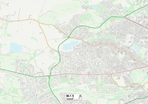
Maps of Montserrat North America are a collection that provide detailed information about the Caribbean island nation
Choose a picture from our Maps Collection for your Wall Art and Photo Gifts
16 items


All Professionally Made to Order for Quick Shipping
-
Maps Collection
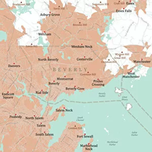
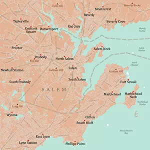
Maps of Montserrat North America are a collection that provide detailed information about the Caribbean island nation. The maps include physical features such as mountains, rivers, and coastlines, as well as political boundaries and population centers. They also provide information about the island's history and culture. They can available in both digital and print formats, allowing users to access them online or purchase them in stores. Maps of Montserrat North America can be used for research purposes, travel planning, or simply to gain a better understanding of the country's geography. With their comprehensive coverage and accurate details, these maps offer an invaluable resource for anyone looking to explore this beautiful Caribbean nation.
+
Our beautiful pictures are available as Framed Prints, Photos, Wall Art and Photo Gifts
The Maps of Montserrat North America collection is a stunning assortment of vintage maps that depict the North American continent. Our collection, available on Media Storehouse, features an array of beautifully crafted and detailed maps from different eras in history. The maps are printed on high-quality paper and come in various sizes to suit any space. These exquisite pieces showcase the evolution of cartography over time, with each map telling its own unique story about the land it represents. From early explorers' sketches to modern-day satellite imagery, our collection offers a glimpse into how our understanding of geography has evolved. Whether you're a history buff or simply looking for an eye-catching piece to adorn your walls, the Maps of Montserrat North America collection is sure to impress. With their intricate details and vivid colors, these prints make excellent conversation starters and add character to any room they grace.
+
What are Maps of Montserrat North America art prints?
Maps of Montserrat North America art prints are high-quality reproductions of vintage maps that depict the island of Montserrat in the Caribbean region. These maps were originally created by cartographers and explorers during the 17th, 18th, and 19th centuries when Montserrat was a British colony. The prints showcase the intricate details and features of the island such as its topography, settlements, landmarks, and natural resources. These art prints are perfect for collectors who appreciate historical artifacts or anyone who has an interest in geography or Caribbean history. They can be used to decorate homes, offices, schools or any other space where one wants to add a touch of elegance and sophistication. Additionally, Maps of Montserrat North America art prints make great gifts for friends or family members who have visited or lived on this beautiful island. These art prints offer a unique glimpse into the past while also providing aesthetic value to any environment they are displayed in.
+
What Maps of Montserrat North America art prints can I buy from Media Storehouse?
We offer a wide range of Montserrat North America art prints that are perfect for decorating your home or office. These maps come in various sizes and styles, including vintage, antique, and contemporary designs. You can choose from different types of maps such as topographic maps, road maps, city maps, and satellite imagery. Some popular options include the 1875 Map of the Island of Montserrat by G.W. Bacon & Co., which shows the island's towns and villages along with its natural features like mountains and rivers. Another great choice is the 1900 Map of British West Indies by Rand McNally & Co., which includes Montserrat along with other Caribbean islands. Whether you're looking for a map to display on your wall or give as a gift to someone who loves geography or history, we have plenty of options to choose from.
+
How do I buy Maps of Montserrat North America art prints?
To purchase Maps of Montserrat North America art prints from Media Storehouse, you can browse our online collection of artwork and select the print that you would like to buy. Once you have chosen your preferred print, simply add it to your cart and proceed to checkout. During the checkout process, you will be prompted to enter your payment details and shipping information. We offer a range of different sizes for their art prints, so make sure to choose the size that best suits your needs. Additionally, we offer a variety of framing options if you prefer your artwork ready-to-hang upon arrival. If you have any questions or concerns about purchasing Maps of Montserrat North America art prints from Media Storehouse, don't hesitate to contact our customer service team for assistance. They are always happy to help with any inquiries or issues that may arise during the buying process.
+
How much do Maps of Montserrat North America art prints cost?
We offer a wide range of Maps of Montserrat North America art prints at varying prices. The cost depends on the size, quality, and type of print that you choose. They have different options available such as canvas prints, framed prints, photographic prints, and fine art prints. The price range for these maps can vary from affordable to high-end depending on your budget and preferences. You can find small-sized maps starting from a few dollars while larger sizes may cost more. Moreover, We provide customers with various customization options like choosing the frame color or adding a mat board to enhance the overall look of your chosen map print. If you are looking for Maps of Montserrat North America art prints at reasonable prices without compromising on quality or variety then Media Storehouse is an excellent place to shop.
+
How will my Maps of Montserrat North America art prints be delivered to me?
Your Maps of Montserrat North America art prints will be delivered to you in a safe and secure manner by Media Storehouse. The company takes great care in packaging your artwork to ensure it arrives at your doorstep undamaged. Your print will be carefully rolled up and placed inside a sturdy tube for protection during transit. Media Storehouse uses reputable courier services to deliver your order, ensuring that it reaches you on time and in excellent condition. You will receive an email notification once your order has been dispatched, along with tracking information so that you can follow its progress. When the package arrives, simply unroll the print and display it as desired. Whether you choose to frame it or hang it as is, your Maps of Montserrat North America art print is sure to add a touch of elegance and sophistication to any room in which it is displayed.