Home > Maps and Charts > Early Maps
Photographic Print : Napoleon / St Helena Map


![]()
Photo Prints from Mary Evans Picture Library
Napoleon / St Helena Map
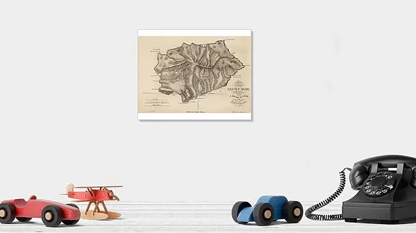
NAPOLEON I Map of the island of Saint Helena during his captivity
Mary Evans Picture Library makes available wonderful images created for people to enjoy over the centuries
Media ID 584860
© Mary Evans Picture Library 2015 - https://copyrighthub.org/s0/hub1/creation/maryevans/MaryEvansPictureID/10038155
1815 1821 Captivity Helena Napoleon Places
10"x8" Photo Print
Step back in time with our Napoleon St Helena Map print from the Media Storehouse collection, brought to you by Mary Evans Picture Library. This captivating image depicts the island of Saint Helena during the intriguing period of Napoleon Bonaparte's exile. The intricate detailing of the map showcases the strategic locations of his residence, Sanezar Point, and Fort Longwood, offering a unique insight into the final chapter of the legendary emperor's life. Add a touch of history to your home or office decor with this evocative, high-quality photographic print.
Photo prints are produced on Kodak professional photo paper resulting in timeless and breath-taking prints which are also ideal for framing. The colors produced are rich and vivid, with accurate blacks and pristine whites, resulting in prints that are truly timeless and magnificent. Whether you're looking to display your prints in your home, office, or gallery, our range of photographic prints are sure to impress. Dimensions refers to the size of the paper in inches.
Our Photo Prints are in a large range of sizes and are printed on Archival Quality Paper for excellent colour reproduction and longevity. They are ideal for framing (our Framed Prints use these) at a reasonable cost. Alternatives include cheaper Poster Prints and higher quality Fine Art Paper, the choice of which is largely dependant on your budget.
Estimated Image Size (if not cropped) is 25.4cm x 17.3cm (10" x 6.8")
Estimated Product Size is 25.4cm x 20.3cm (10" x 8")
These are individually made so all sizes are approximate
Artwork printed orientated as per the preview above, with landscape (horizontal) orientation to match the source image.
EDITORS COMMENTS
This fascinating historical print depicts a map of the island of Saint Helena during Napoleon Bonaparte's captivity in 1815. The detailed map showcases the various locations on the remote island where Napoleon was exiled after his defeat at the Battle of Waterloo. From Longwood House, where he resided during his time on the island, to Deadwood Plain where he would often take walks, this map provides a glimpse into Napoleon's daily life during his final years.
The intricate details and accuracy of this map offer a unique perspective on one of history's most iconic figures. It allows us to visualize the confines within which Napoleon lived out his days far from the grandeur and power he once held as Emperor of France.
As we study this map, we can't help but feel a sense of intrigue and curiosity about Napoleon's thoughts and emotions as he navigated through his confinement on Saint Helena. It serves as a reminder of both the heights of ambition and glory that Napoleon achieved, as well as the depths of despair and isolation that marked his later years.
Overall, this print is not just a geographical representation but also a window into an important chapter in world history - making it a valuable addition to any collection or display showcasing significant moments from the past.
MADE IN THE USA
Safe Shipping with 30 Day Money Back Guarantee
FREE PERSONALISATION*
We are proud to offer a range of customisation features including Personalised Captions, Color Filters and Picture Zoom Tools
SECURE PAYMENTS
We happily accept a wide range of payment options so you can pay for the things you need in the way that is most convenient for you
* Options may vary by product and licensing agreement. Zoomed Pictures can be adjusted in the Cart.