Home > Maps and Charts > World
Canvas Print : Mercator / World Map / 1587


![]()
Canvas Prints from Mary Evans Picture Library
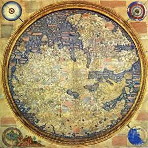
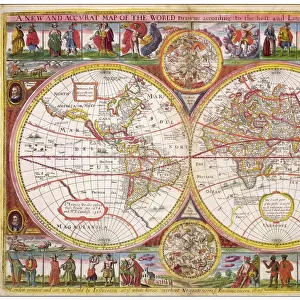
Mercator / World Map / 1587
A map of the world by Gerhard Mercator
Mary Evans Picture Library makes available wonderful images created for people to enjoy over the centuries
Media ID 580904
© Mary Evans Picture Library 2015 - https://copyrighthub.org/s0/hub1/creation/maryevans/MaryEvansPictureID/10025620
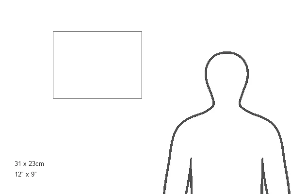
12"x9" (30x23cm) Canvas Print
Introducing the captivating Mercator Canvas Print from Media Storehouse, brought to you in partnership with Mary Evans Picture Library from Mary Evans Prints Online. This stunning representation of the world as it was known in 1587 is an exquisite addition to any space, transporting you back in time with its intricate detail and historical significance. Crafted with the finest materials, our Canvas Prints faithfully reproduce the rich colors and textures of the original map by renowned cartographer Gerhard Mercator. The meticulously detailed World Map, with its bold lines and vivid hues, invites you to explore the wonders of the known world as it appeared over 400 years ago. Bring the captivating history of cartography into your home or office with the timeless beauty of our Mercator Canvas Print. Each print is individually crafted with care, ensuring the highest quality and authenticity. Elevate your space with this mesmerizing piece of art and history.
Delivered stretched and ready to hang our premium quality canvas prints are made from a polyester/cotton blend canvas and stretched over a 1.25" (32mm) kiln dried knot free wood stretcher bar. Packaged in a plastic bag and secured to a cardboard insert for safe transit.
Canvas Prints add colour, depth and texture to any space. Professionally Stretched Canvas over a hidden Wooden Box Frame and Ready to Hang
Estimated Product Size is 30.5cm x 22.9cm (12" x 9")
These are individually made so all sizes are approximate
Artwork printed orientated as per the preview above, with landscape (horizontal) orientation to match the source image.
FEATURES IN THESE COLLECTIONS
> Maps and Charts
> Early Maps
> Maps and Charts
> World
> Mary Evans Prints Online
> Maps
EDITORS COMMENTS
This image showcases the intricately detailed and historically significant 1587 World Map by the renowned cartographer Gerhard Mercator. One of the most influential maps in history, Mercator's map is a testament to the advancements in cartography during the Renaissance period. Mercator, a Flemish cartographer, created this map as part of his atlas "Atlas sive Cosmographiae Universales," published in Duisburg, Germany. This map was the first to use Mercator's new projection, which became the standard for nautical charts and navigational maps for centuries. The Mercator projection, with its rectangular shape and constant scale along the meridians, allowed sailors to maintain a consistent course and navigate more accurately than ever before. The map is adorned with elaborate decorative elements, including intricate cartouches, coats of arms, and elaborate title inscriptions. The map's border features various scenes from biblical history, as well as depictions of the four continents known at the time: Europe, Asia, Africa, and America. The map's meticulous detail and innovative projection revolutionized cartography and played a crucial role in the Age of Discovery. It allowed explorers and navigators to chart new territories and expand European knowledge of the world. This historic map is not only a beautiful work of art but also a significant piece of historical and scientific importance. The Mary Evans Picture Library is proud to offer this high-resolution image of Gerhard Mercator's 1587 World Map for researchers, educators, and anyone interested in the history of cartography, exploration, or the world as it was known during the Renaissance period.
MADE IN THE USA
Safe Shipping with 30 Day Money Back Guarantee
FREE PERSONALISATION*
We are proud to offer a range of customisation features including Personalised Captions, Color Filters and Picture Zoom Tools
SECURE PAYMENTS
We happily accept a wide range of payment options so you can pay for the things you need in the way that is most convenient for you
* Options may vary by product and licensing agreement. Zoomed Pictures can be adjusted in the Cart.