Home > Europe > United Kingdom > Northern Ireland > Castles
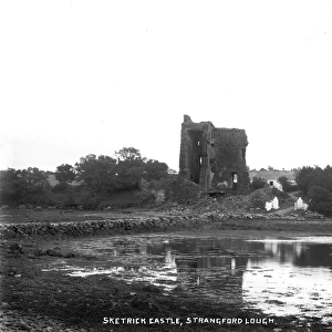
Sketerick Castle Across the Dorn

![]()
Wall Art and Photo Gifts from Mary Evans Picture Library
Sketerick Castle Across the Dorn
Sketerick Castle Across the Dorn - a side view of the derelict Castle, with the Lough in the foreground. (Location: Northern Ireland: County Down: Sketrick). Date: circa early 1900s
Mary Evans Picture Library makes available wonderful images created for people to enjoy over the centuries
Media ID 14364655
© National Museums NI / Mary Evans
Across Derelict Foreground Lough Dorn
FEATURES IN THESE COLLECTIONS
> Europe
> United Kingdom
> Northern Ireland
> Castles
> Europe
> United Kingdom
> Northern Ireland
> County Down
> Related Images
> Europe
> United Kingdom
> Northern Ireland
> Down
Sketerick Castle Across the Dorn
EDITORS COMMENTS
is an evocative photograph capturing the haunting beauty of Sketerick Castle in County Down, Northern Ireland. The image, taken from the late 19th or early 20th century, presents a side view of the derelict castle with the tranquil waters of the Lough in the foreground. The castle, once a grand and imposing structure, now stands as a testament to the passage of time and the relentless march of nature. Sketerick Castle, located in the picturesque County Down region, was likely built during the late 16th or early 17th century. The castle's strategic location on the shores of the Lough of Carlingford made it an important defensive structure during times of conflict. However, over the centuries, the castle fell into disrepair, and today, only the crumbling walls remain. The photograph's title, "Sketerick Castle Across the Dorn," refers to the narrow strip of land, or "dorn," that separates the castle from the Lough. The name "Sketerick" is believed to derive from the Irish "Sceitirig," meaning "wooded hill." The castle's proximity to the water and the surrounding woodlands adds to its mystique and allure. This photograph offers a glimpse into the rich history of Northern Ireland and the fascinating stories that lie hidden within its landscapes. The image invites us to reflect on the past and contemplate the enduring power of nature to reclaim what was once a symbol of human strength and dominion. The serene beauty of the Lough and the haunting ruins of Sketerick Castle serve as a poignant reminder of the transient nature of human endeavors and the enduring power of the natural world.
MADE IN THE USA
Safe Shipping with 30 Day Money Back Guarantee
FREE PERSONALISATION*
We are proud to offer a range of customisation features including Personalised Captions, Color Filters and Picture Zoom Tools
FREE COLORIZATION SERVICE
You can choose advanced AI Colorization for this picture at no extra charge!
SECURE PAYMENTS
We happily accept a wide range of payment options so you can pay for the things you need in the way that is most convenient for you
* Options may vary by product and licensing agreement. Zoomed Pictures can be adjusted in the Cart.