Home > Europe > United Kingdom > England > London > Transport > Railway
Russian advance in Balkans by G. H. Davis

![]()
Wall Art and Photo Gifts from Mary Evans Picture Library
Russian advance in Balkans by G. H. Davis
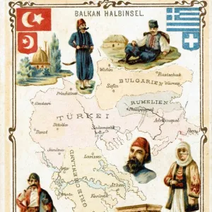
Russias advance in the Balkans during the Second World War: a pictorial map of the terrain. The Eastern Balkans and Carpathian passes: a map showing mountain passes, railways and oilfields. Date: 1944
Mary Evans Picture Library makes available wonderful images created for people to enjoy over the centuries
Media ID 14133443
© Illustrated London News Ltd/Mary Evans
1944 Advance Advancing Balkan Balkans Carpathian Davis Hungary Maps Oilfield Oilfields Pass Passes Pictorial Poland Railways Romania Soviet Terrain Ussr
FEATURES IN THESE COLLECTIONS
> Europe
> United Kingdom
> England
> London
> Transport
> Railway
> Maps and Charts
> Early Maps
EDITORS COMMENTS
This evocative map, titled "Russia's Advance in the Balkans during the Second World War: A Pictorial Map of the Terrain. The Eastern Balkans and Carpathian Passes," was created by renowned cartographer G.H. Davis in 1944. The map provides a detailed and intricate representation of the Eastern Balkans and Carpathian passes during the pivotal year of the Second World War. As the Allied forces pushed deeper into Europe, the Soviet Union made significant gains in the Eastern Balkans, advancing through Poland, Hungary, and Romania. This map offers a unique perspective on the strategic importance of the region during the war, highlighting key terrain features, mountain passes, railways, and oilfields. The map's intricate detailing of the mountainous terrain, particularly the Carpathian passes, emphasizes the challenges faced by both the advancing Soviet forces and the retreating Axis powers. The railways and oilfields depicted on the map underscore the importance of transportation and resources in the conflict. The Black Sea and the surrounding regions are also featured prominently, illustrating the strategic significance of the sea as a critical transportation route and a potential invasion front. The map's historical context is further emphasized by its title, which places the events of 1944 within the broader context of the Second World War. G.H. Davis's "Russia's Advance in the Balkans during the Second World War: A Pictorial Map of the Terrain. The Eastern Balkans and Carpathian Passes" is a valuable historical document that offers insights into the military, geographical, and strategic aspects of the Eastern Front during the Second World War.
MADE IN THE USA
Safe Shipping with 30 Day Money Back Guarantee
FREE PERSONALISATION*
We are proud to offer a range of customisation features including Personalised Captions, Color Filters and Picture Zoom Tools
SECURE PAYMENTS
We happily accept a wide range of payment options so you can pay for the things you need in the way that is most convenient for you
* Options may vary by product and licensing agreement. Zoomed Pictures can be adjusted in the Cart.