Home > Europe > Italy > Veneto > Venice
PTOLEMY, Claudius Ptolemaeus ( c. AD 100 - c

![]()
Wall Art and Photo Gifts from Mary Evans Picture Library
PTOLEMY, Claudius Ptolemaeus ( c. AD 100 - c
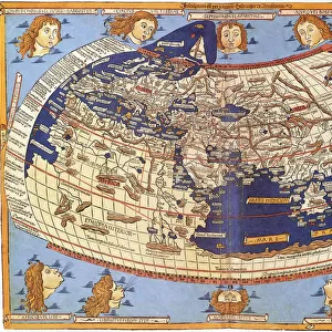
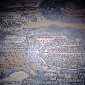
" PTOLEMY, Claudius Ptolemaeus ( c. AD 100 - c. AD 170). Egyptian astronomer, mathematician and geographer. Map of the Ancient World. From the work " Ptolomeus Geographicorum Libri". ITALY. Venice. Biblioteca nazionale marciana (St. Marks Library)."
Mary Evans Picture Library makes available wonderful images created for people to enjoy over the centuries
Media ID 8269213
© Mary Evans Picture Library 2015 - https://copyrighthub.org/s0/hub1/creation/maryevans/MaryEvansPictureID/10685897
Astronomer Biblioteca Claudius Geographer Libri Marciana Mathematician Nazionale Ptolemaeus Ptolemy Venice
FEATURES IN THESE COLLECTIONS
> Europe
> Italy
> Veneto
> Venice
> Maps and Charts
> Early Maps
> Maps and Charts
> Italy
> Maps and Charts
> World
EDITORS COMMENTS
1. Title: Ptolemy, Claudius Ptolemaeus (c. AD 100 - c. AD 170): Egyptian Astronomer, Mathematician, and Geographer 2. Description: This image showcases a rare and intriguing map, titled "Ptolomeus Geographicorum Libri," which is a significant work by the ancient world's renowned scholar, Claudius Ptolemaeus, also known as Ptolemy. Born in Egypt around AD 100, Ptolemy was a polymath, excelling in various fields such as astronomy, mathematics, and geography. 3. Setting: The map, housed in the prestigious Biblioteca Nazionale Marciana (St. Mark's Library) in Venice, Italy, is a testament to the enduring legacy of Ptolemy's intellectual prowess. The map, displayed in a horizontal, colorful format, is a fascinating glimpse into the ancient world's understanding of geography. 4. Background: Ptolemy's work, "Geographia," which includes "Ptolomeus Geographicorum Libri," was groundbreaking in its time, providing a systematic and comprehensive description of the known world. This map, specifically, is a crucial piece of evidence of the ancient world's geographical knowledge and the influence of Ptolemy's work on the development of cartography. 5. Significance: The map's preservation in the Biblioteca Nazionale Marciana is a reminder of the importance of historical libraries and their role in safeguarding our collective cultural heritage. Ptolemy's work continues to inspire and influence scholars and researchers in various fields, demonstrating the timeless relevance of ancient knowledge. 6. Conclusion: This image of the "Ptolomeus Geographicorum Libri" map offers a captivating glimpse into the ancient world, showcasing the intellectual achievements of Ptolemy, the Egyptian polymath, and the enduring significance of the Biblioteca Nazionale Marciana in preserving our shared cultural heritage.
MADE IN THE USA
Safe Shipping with 30 Day Money Back Guarantee
FREE PERSONALISATION*
We are proud to offer a range of customisation features including Personalised Captions, Color Filters and Picture Zoom Tools
SECURE PAYMENTS
We happily accept a wide range of payment options so you can pay for the things you need in the way that is most convenient for you
* Options may vary by product and licensing agreement. Zoomed Pictures can be adjusted in the Cart.