Home > Europe > Italy > Sicily > Messina
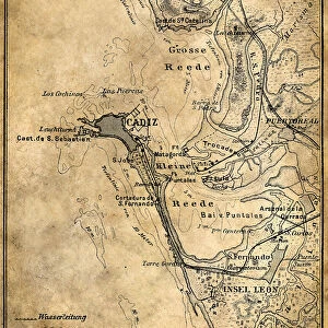
Portolan Atlas, 1587. Map of the Iberian Peninsula

![]()
Wall Art and Photo Gifts from Mary Evans Picture Library
Portolan Atlas, 1587. Map of the Iberian Peninsula
Portolan Atlas, 1587. Map of the Iberian Peninsula, the north coastline of Africa and the Vasque Countrys region in France. Made in Messina. Facsimile. Miniature Painting. SPAIN. Madrid. National Library
Mary Evans Picture Library makes available wonderful images created for people to enjoy over the centuries
Media ID 8281785
© Mary Evans Picture Library 2015 - https://copyrighthub.org/s0/hub1/creation/maryevans/MaryEvansPictureID/10681999
Atlas Cartographic Coast Line Countrys Facsimile Iberian Illuminated Manuscript Manuscripts Messina Miniatures Peninsula Portolan Region Made
FEATURES IN THESE COLLECTIONS
> Africa
> Related Images
> Europe
> Italy
> Sicily
> Messina
> Maps and Charts
> Spain
EDITORS COMMENTS
1. Title: A Glimpse into the Past: The Portolan Atlas of 1587 - A Masterpiece of Cartographic Art This image showcases a fascinating piece of cartographic history: the Portolan Atlas of 1587, a meticulously crafted map of the Iberian Peninsula, the north coastline of Africa, and the Vasque Country region in France. The map, housed in the National Library of Spain in Madrid, is a testament to the artistic and cartographic achievements of the late 16th century. Created in Messina, this intricately detailed map is a prime example of a portolan chart, a type of European map that originated in the 13th century. The map's title, "Portolan Atlas," refers to the Italian mariners who developed this cartographic tradition, using rhumb lines to represent the constant courses sailors would follow to navigate the Mediterranean Sea. The map's vibrant colors and intricate details are a result of its miniature painting and manuscript origins. Each coastal city, island, and landmass is meticulously depicted, with an emphasis on accuracy and geographical detail. The map's depiction of the Iberian Peninsula reveals the political divisions of the time, with the kingdoms of Castile, Aragon, and Navarre clearly distinguishable. The north coastline of Africa is also represented, with the Strait of Gibraltar connecting the Mediterranean Sea to the Atlantic Ocean. The Vasque Country region in France is also shown, highlighting the connections between the Iberian Peninsula and Europe during this period. This Portolan Atlas is a facsimile, a reproduction of the original map, allowing modern viewers to appreciate the beauty and historical significance of this remarkable cartographic masterpiece. The map's intricate details and artistic merit serve as a reminder of the rich cartographic heritage that continues to inspire and inform our understanding of the world today.
MADE IN THE USA
Safe Shipping with 30 Day Money Back Guarantee
FREE PERSONALISATION*
We are proud to offer a range of customisation features including Personalised Captions, Color Filters and Picture Zoom Tools
SECURE PAYMENTS
We happily accept a wide range of payment options so you can pay for the things you need in the way that is most convenient for you
* Options may vary by product and licensing agreement. Zoomed Pictures can be adjusted in the Cart.