Home > Europe > United Kingdom > England > Essex > Rochford
1840s Victorian Map of Essex

![]()
Wall Art and Photo Gifts from Mary Evans Picture Library
1840s Victorian Map of Essex
Mary Evans Picture Library makes available wonderful images created for people to enjoy over the centuries
Media ID 32350810
© The Keasbury-Gordon Photograph Archive / Mary Evans
1840s Bishop Chelmsford Colchester Epping Essex Gravesend Harwich Railways Rochford Romford Stortford Thaxted
FEATURES IN THESE COLLECTIONS
> Europe
> United Kingdom
> England
> Chelmsford
> Europe
> United Kingdom
> England
> Essex
> Chelmsford
> Europe
> United Kingdom
> England
> Essex
> Colchester
> Europe
> United Kingdom
> England
> Essex
> Epping
> Europe
> United Kingdom
> England
> Essex
> Harwich
> Europe
> United Kingdom
> England
> Essex
> Rochford
> Europe
> United Kingdom
> England
> Essex
> Romford
> Europe
> United Kingdom
> England
> Essex
> Thaxted
> Europe
> United Kingdom
> England
> London
> River Thames
> Europe
> United Kingdom
> England
> Maps
> Mary Evans Prints Online
> New Images July 2023
EDITORS COMMENTS
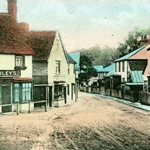
Step back in time with this stunning 1840s Victorian Map of Essex, a true vintage treasure from the Keasbury-Gordon Photograph Archive Collection. This beautifully detailed map showcases the historic county of Essex in all its glory, featuring towns like Rochford, Romford, Colchester, Harwich, Chelmsford, Thaxted, Epping, and Bishop's Stortford.
The intricate design of this map is a testament to the craftsmanship of cartographers from the early 19th century. The River Thames winds its way through the county, connecting bustling cities and charming villages alike. Railway lines crisscross the landscape, highlighting the importance of transportation during this era.
As you study this map closely, you can almost imagine yourself traveling back in time to explore Essex as it once was. From Gravesend in the west to Harwich in the east, every corner of this historic county is waiting to be discovered.
Whether you're a history buff or simply appreciate beautiful antique prints, this 1840s Victorian Map of Essex is sure to captivate your imagination. Display it proudly in your home or office as a conversation piece that will transport you to another era every time you gaze upon it.
MADE IN THE USA
Safe Shipping with 30 Day Money Back Guarantee
FREE PERSONALISATION*
We are proud to offer a range of customisation features including Personalised Captions, Color Filters and Picture Zoom Tools
SECURE PAYMENTS
We happily accept a wide range of payment options so you can pay for the things you need in the way that is most convenient for you
* Options may vary by product and licensing agreement. Zoomed Pictures can be adjusted in the Cart.