Home > Europe > United Kingdom > England > London > Towns > Spitalfields
Railway map, Aldgate, Bishopsgate, Haydon Square, London

![]()
Wall Art and Photo Gifts from Mary Evans Picture Library
Railway map, Aldgate, Bishopsgate, Haydon Square, London
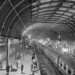
Railway map, Aldgate, Bishopsgate, Haydon Square, Mansion House, Spitalfields & Whitechapel, London, with colour coding of the various railway companies. Date: 1922
Mary Evans Picture Library makes available wonderful images created for people to enjoy over the centuries
Media ID 23144186
© Mary Evans / Pharcide
Aldgate Bishopsgate Coal Coding Companies Docks Goods Haydon Junction Junctions Lines Links Liverpool Mansion Maps Stations 1922
FEATURES IN THESE COLLECTIONS
> Europe
> United Kingdom
> England
> London
> River Thames
> Europe
> United Kingdom
> England
> London
> Towns
> Spitalfields
> Europe
> United Kingdom
> England
> London
> Towns
> Whitechapel
> Europe
> United Kingdom
> England
> London
> Transport
> Railway
> Europe
> United Kingdom
> England
> London
> Transport
> Stations
> Maps and Charts
> Related Images
> Mary Evans Prints Online
> New Images August 2021
EDITORS COMMENTS
1. Title: A Vibrant Snapshot of Transport Connections in 1920s London: Aldgate, Bishopsgate, Haydon Square, and Surrounding Railway Network 2. In this 1922 railway map of London, we delve into the rich transport history of the city, focusing on the bustling areas of Aldgate, Bishopsgate, Haydon Square, Mansion House, Spitalfields, and Whitechapel. The intricate web of railway lines and links, color-coded to represent various railway companies, reveals the extensive network that connected the city during the 1920s. 3. The map showcases the complex railway junctions at Aldgate and Bishopsgate, which served as crucial transportation hubs for both passengers and goods. The intricate network of railway lines crisscrossing the map reveals the extensive reach of the railway system, linking various parts of the city and beyond. 4. The map highlights the importance of railways as a primary mode of transportation during the 1920s, with lines extending towards the docks along the River Thames, providing essential links to the city's bustling port activities. The presence of coal lines further underscores the significance of the railway network in supplying fuel to power the city's industries. 5. The color-coding of the railway companies adds an interesting layer to the map, providing a visual representation of the competition and cooperation that existed between different railway operators during the era. The map also reveals the proximity of various railway stations, such as Mansion House, Liverpool Street, and Fenchurch Street, to the depicted areas, making it an essential tool for navigating the city's transport system. 6. This beautifully detailed railway map offers a fascinating glimpse into the transport infrastructure of London during the 1920s, providing valuable insights into the city's history and the role of railways in shaping its urban landscape.
MADE IN THE USA
Safe Shipping with 30 Day Money Back Guarantee
FREE PERSONALISATION*
We are proud to offer a range of customisation features including Personalised Captions, Color Filters and Picture Zoom Tools
SECURE PAYMENTS
We happily accept a wide range of payment options so you can pay for the things you need in the way that is most convenient for you
* Options may vary by product and licensing agreement. Zoomed Pictures can be adjusted in the Cart.