Home > Europe > France > Paris > Maps
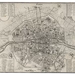
Map of the 17th Arrondissement, Paris, France

![]()
Wall Art and Photo Gifts from Mary Evans Picture Library
Map of the 17th Arrondissement, Paris, France
Map of the 17th Arrondissement, Quartier des Epinettes, Paris, France. Date: circa 1900s
Mary Evans Picture Library makes available wonderful images created for people to enjoy over the centuries
Media ID 23272426
© Mary Evans Picture Library
Arrondissement Avenue Balagny Bessieres Clichy Epinettes Maps Michel Ouen Quartier Roads
FEATURES IN THESE COLLECTIONS
> Europe
> France
> Paris
> Maps
> Mary Evans Prints Online
> New Images August 2021
EDITORS COMMENTS
Step back in time with this print of the 17th Arrondissement in Paris, France, circa 1900s. This intricately detailed map showcases the Quartier des Epinettes, a charming and historic neighborhood located in the northwestern part of the city. The map highlights the labyrinthine network of roads and streets that crisscross this picturesque area, including Rue Balagny, Avenue St. Ouen, and Clichy. These thoroughfares have been a part of Parisian life for over a century, connecting the community's residents to the heart of the city. One of the most notable landmarks depicted on the map is the Church of St. Michel-de-Bessières, located at the intersection of Rue Balagny and Rue des Epinettes. This beautiful church, with its distinctive red-tiled roof and ornate facade, has been a spiritual and architectural landmark of the neighborhood for over 150 years. The map also reveals the presence of several markets and commercial areas, such as the famous Marché de St. Ouen, which has been a hub of activity for antique dealers, flea market vendors, and food stalls since the late 1800s. This vintage map offers a fascinating glimpse into the history and character of the 17th Arrondissement, a neighborhood that continues to captivate visitors and locals alike with its rich cultural heritage and unique charm.
MADE IN THE USA
Safe Shipping with 30 Day Money Back Guarantee
FREE PERSONALISATION*
We are proud to offer a range of customisation features including Personalised Captions, Color Filters and Picture Zoom Tools
SECURE PAYMENTS
We happily accept a wide range of payment options so you can pay for the things you need in the way that is most convenient for you
* Options may vary by product and licensing agreement. Zoomed Pictures can be adjusted in the Cart.