Home > Europe > United Kingdom > England > London > Boroughs > Bexley
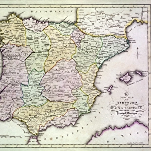
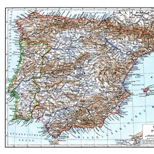
Map of South Spain

![]()
Wall Art and Photo Gifts from Mary Evans Picture Library
Map of South Spain
Map of South Spain - Black and white map, heavy lines designating provinces Date: circa 1890s
Mary Evans Picture Library makes available wonderful images created for people to enjoy over the centuries
Media ID 14415784
© The Boswell Collection, Bexley Heritage Trust / Mary Evans
Gibraltar Heavy Lines Overseas Provinces Territory
FEATURES IN THESE COLLECTIONS
> Europe
> United Kingdom
> England
> London
> Boroughs
> Bexley
> Maps and Charts
> Spain
EDITORS COMMENTS
1. Title: A Glimpse into the Past: A Black and White Map of South Spain from the Late 19th Century This evocative black and white map print transports us back in time to the late 19th century, offering a captivating glimpse into the geographical makeup of South Spain during an era of significant historical change. The map, which dates back to approximately the 1890s, showcases the provinces of South Spain with heavy lines, meticulously delineating their boundaries. The map's antiquated charm is further accentuated by its intricate design, reminiscent of a lantern slide that would have once been projected onto a screen for educational or entertainment purposes. The map's title, "South Spain," is written in bold, clear letters at the top, while the names of each province are neatly inscribed in smaller font beneath. One cannot help but notice the prominent presence of the British territory of Gibraltar, situated at the southern tip of the Iberian Peninsula. The map's historical significance is amplified by this inclusion, as the late 19th century marked a time of intense political tension between Spain and Britain over the sovereignty of Gibraltar. This map serves as an invaluable historical artifact, providing us with a tangible connection to the past and shedding light on the geopolitical landscape of South Spain during the late 19th century. Its heavy lines and monochromatic palette only add to its allure, making it a must-have for history enthusiasts, educators, and anyone with a penchant for the nostalgic charm of bygone eras.
MADE IN THE USA
Safe Shipping with 30 Day Money Back Guarantee
FREE PERSONALISATION*
We are proud to offer a range of customisation features including Personalised Captions, Color Filters and Picture Zoom Tools
SECURE PAYMENTS
We happily accept a wide range of payment options so you can pay for the things you need in the way that is most convenient for you
* Options may vary by product and licensing agreement. Zoomed Pictures can be adjusted in the Cart.