Home > Arts > Artists > O > Abraham Ortelius
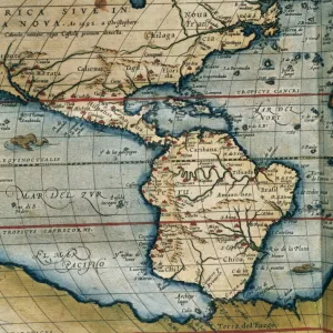
Map of the Kingdom of Naples. Theatrum Orbis Terrarum by Abr

![]()
Wall Art and Photo Gifts from Mary Evans Picture Library
Map of the Kingdom of Naples. Theatrum Orbis Terrarum by Abr
Map of the Kingdom of Naples. Theatrum Orbis Terrarum by Abraham Ortelius (1527-1598). First Edition. Antwerp, 1574. Library of Catalonia. Barcelona. Spain
Mary Evans Picture Library makes available wonderful images created for people to enjoy over the centuries
Media ID 14333267
© Thaliastock / Mary Evans
1574 Abraham Antwerp Atlas Carthography Cartographic Cartography Catalonia Continent Edition Flanders Flemish Geography Naples Orbis Ortelius Ortels Terrarum Theatrum
FEATURES IN THESE COLLECTIONS
> Arts
> Artists
> O
> Abraham Ortelius
> Europe
> Italy
> Campania
> Naples
> Maps and Charts
> Abraham Ortelius
> Maps and Charts
> Early Maps
EDITORS COMMENTS
This stunning map print, titled "Map of the Kingdom of Naples" from "Theatrum Orbis Terrarum," is a testament to the extraordinary cartographic achievements of the 16th century. Created by the renowned Flemish cartographer Abraham Ortelius (1527-1598) in Antwerp, Belgium, this first edition map was published in 1574. The map is now proudly housed in the Library of Catalonia in Barcelona, Spain. Ortelius' "Theatrum Orbis Terrarum," often referred to as the first modern atlas, revolutionized the world of cartography by compiling a comprehensive collection of maps in a single volume. This map of the Kingdom of Naples is a prime example of Ortelius' meticulous attention to detail and accuracy. The map provides a captivating depiction of the Italian peninsula and the Mediterranean Sea during the European Age of Discovery. The Kingdom of Naples, located in the southern part of Italy, is prominently displayed, with its intricate borders and major cities labeled in Latin. The map also highlights the strategic position of Naples as a gateway to the Mediterranean and the importance of its ports for maritime trade. The map features an impressive array of cartographic details, including the delineation of the Italian peninsula, the Adriatic and Ionian Seas, and the surrounding European and African coastlines. The inclusion of a vessel navigating the waters off the coast of Sicily adds a sense of dynamism and exploration to the map. The intricate cartouche at the bottom of the map is adorned with elaborate decorative elements, further emphasizing the artistic and intellectual prowess of the time. This map is not only a valuable historical document but also a beautiful work of art that transports us back to the Age of Discovery.
MADE IN THE USA
Safe Shipping with 30 Day Money Back Guarantee
FREE PERSONALISATION*
We are proud to offer a range of customisation features including Personalised Captions, Color Filters and Picture Zoom Tools
SECURE PAYMENTS
We happily accept a wide range of payment options so you can pay for the things you need in the way that is most convenient for you
* Options may vary by product and licensing agreement. Zoomed Pictures can be adjusted in the Cart.