Home > Europe > Luxembourg > Maps
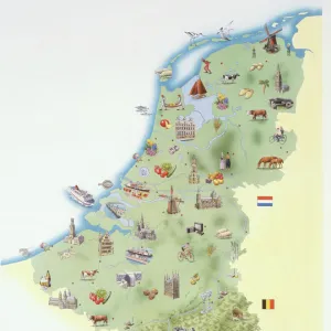
Friesland. Map of North of Netherlands

![]()
Wall Art and Photo Gifts from Mary Evans Picture Library
Friesland. Map of North of Netherlands
Friesland. Map of North of Netherlands. Made by Michaelis Tramezini, 1558. Printed by Iacobus Bossius
Mary Evans Picture Library makes available wonderful images created for people to enjoy over the centuries
Media ID 14337065
© Thaliastock / Mary Evans
1558 Cartography Friesland Luxembourg Mapping Michaelis Netherlands Frisia
FEATURES IN THESE COLLECTIONS
> Europe
> Luxembourg
> Maps
> Europe
> Netherlands
> Maps
> Maps and Charts
> Early Maps
> Maps and Charts
> Luxembourg
> Maps and Charts
> Netherlands
EDITORS COMMENTS
This intriguing map print, titled "Friesland. Map of the North of the Netherlands," dates back to the 16th century, specifically 1558. The map was created by the cartographer Michaelis Tramezini and was later printed by Iacobus Bossius. At the time, Europe was undergoing a period of significant cartographic advancement, and this map is a testament to the progress made during this age of discovery. Friesland, also known as Frisia, is a historical region located in the north of the Netherlands. The map provides a detailed and accurate representation of the area during the Renaissance period. It includes the Frisian Islands, the province of Groningen, and parts of modern-day Germany and Denmark. The map also features various towns, rivers, and other geographical features, making it an invaluable resource for historians and scholars studying the region during this time. The map's antiquity is evident in its intricate and ornate design. The cartouche, or decorative border, is adorned with elaborate engravings of mythological figures and scenes, reflecting the artistic sensibilities of the time. The map's title and other text are written in Latin, further emphasizing its historical significance. Despite its age, the map remains an impressive feat of cartography. Its accuracy and attention to detail are remarkable, providing a window into the past and shedding light on the historical geography of Friesland and the surrounding areas. This map print is a valuable addition to any collection of historical maps or European cartography and offers a fascinating glimpse into the past.
MADE IN THE USA
Safe Shipping with 30 Day Money Back Guarantee
FREE PERSONALISATION*
We are proud to offer a range of customisation features including Personalised Captions, Color Filters and Picture Zoom Tools
SECURE PAYMENTS
We happily accept a wide range of payment options so you can pay for the things you need in the way that is most convenient for you
* Options may vary by product and licensing agreement. Zoomed Pictures can be adjusted in the Cart.