Home > Europe > Italy > Sicily > Messina
Chart of Mediterranean Sea by Petru Russu, made

![]()
Wall Art and Photo Gifts from Mary Evans Picture Library
Chart of Mediterranean Sea by Petru Russu, made
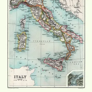
Chart of Mediterranean Sea by Petru Russu, made in Messina in 1508. SPAIN. Barcelona. Barcelona Maritime Museum. Proc: ITALY. Messina
Mary Evans Picture Library makes available wonderful images created for people to enjoy over the centuries
Media ID 8284405
© Mary Evans/M.C.Esteban/Iberfoto
Barcelona Chart Insides Italia Italians Maritime Mediterranean Messina Peninsula Europeans Made
FEATURES IN THESE COLLECTIONS
> Europe
> Italy
> Sicily
> Messina
> Maps and Charts
> Related Images
EDITORS COMMENTS
This stunning and intricately detailed chart, entitled "Chart of the Mediterranean Sea" by Petru Russu, dates back to the year 1508 and was created in the beautiful Italian city of Messina. Housed in the esteemed Barcelona Maritime Museum in Spain, this historic map offers a glimpse into the European exploration and cartography of the Mediterranean Sea during the Renaissance period. The chart is presented in a horizontal format and is adorned with vibrant colors, adding to its aesthetic appeal. The Italian city of Messina, located at the northeastern tip of Sicily, served as the birthplace of this remarkable work. The chart is a testament to the Italian and European cartographic tradition, showcasing the Mediterranean Sea and the surrounding lands with remarkable accuracy for the time. The intricate peninsula outlines, islands, and coastal features are all meticulously rendered, providing a window into the geography of the Mediterranean as it was known during the late 15th century. The chart also includes various annotations and notations, likely used by mariners and navigators of the time to aid in their voyages across the sea. This chart by Petru Russu is a significant historical artifact, offering a glimpse into the European exploration and cartographic tradition of the Mediterranean Sea during the Renaissance period. Its presence in the Barcelona Maritime Museum in Spain is a testament to the rich cultural exchange that took place between Italy and Spain during this time, and serves as a reminder of the enduring importance of maritime history and cartography in understanding our past.
MADE IN THE USA
Safe Shipping with 30 Day Money Back Guarantee
FREE PERSONALISATION*
We are proud to offer a range of customisation features including Personalised Captions, Color Filters and Picture Zoom Tools
SECURE PAYMENTS
We happily accept a wide range of payment options so you can pay for the things you need in the way that is most convenient for you
* Options may vary by product and licensing agreement. Zoomed Pictures can be adjusted in the Cart.