Home > Maps and Charts > Africa
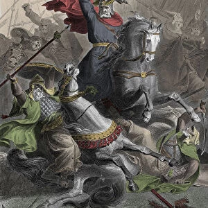
Charlemagne Era Map

![]()
Wall Art and Photo Gifts from Mary Evans Picture Library
Charlemagne Era Map
A map of Europe, Asia and Africa in the time of Charlemagne and the Saracen empire. Date: circa 800
Mary Evans Picture Library makes available wonderful images created for people to enjoy over the centuries
Media ID 14295240
© Mary Evans Picture Library/DOUGLAS MCCARTHY
FEATURES IN THESE COLLECTIONS
> Africa
> Related Images
> Asia
> Related Images
> Europe
> Related Images
> Maps and Charts
> Early Maps
EDITORS COMMENTS
This Charlemagne Era Map, dated circa 800, offers a fascinating glimpse into the geographical knowledge of Europe, Asia, and Africa during the reign of Charlemagne (768-814), the King of the Franks and the first Holy Roman Emperor. Charlemagne's empire, which encompassed much of modern-day Western Europe, was a significant political and cultural force during this period. The map, which is believed to have been created within the Frankish court, illustrates the extent of Charlemagne's territories, as well as the lands of his contemporaries, including the Umayyad Caliphate, or Saracen Empire, which controlled much of the Iberian Peninsula, North Africa, and the Middle East. The map's intricate detailing and accurate representation of known territories for the time demonstrate the advanced cartographic knowledge and skills of the Frankish scribes and geographers. The map's borders are adorned with elaborate decorative elements, including intricate patterns and illustrations of various mythical creatures, reflecting the artistic and cultural richness of the Charlemagne Era. The map also includes various annotations and labels, providing valuable historical information about the different regions and their inhabitants. This map is an essential historical artifact, offering insights into the political, cultural, and geographical landscape of Europe, Asia, and Africa during the early Middle Ages. Its intricate details and decorative elements provide a captivating visual representation of the world as it was known during the time of Charlemagne and the Saracen Empire.
MADE IN THE USA
Safe Shipping with 30 Day Money Back Guarantee
FREE PERSONALISATION*
We are proud to offer a range of customisation features including Personalised Captions, Color Filters and Picture Zoom Tools
SECURE PAYMENTS
We happily accept a wide range of payment options so you can pay for the things you need in the way that is most convenient for you
* Options may vary by product and licensing agreement. Zoomed Pictures can be adjusted in the Cart.