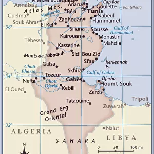
Home > Africa > Tunisia > Bizerte
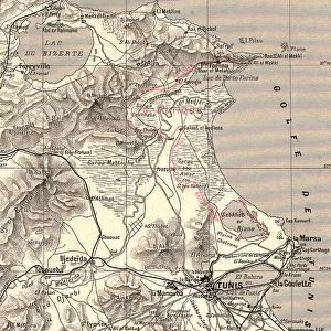
Bizerta and environs by G. H. Davis

![]()
Wall Art and Photo Gifts from Mary Evans Picture Library
Bizerta and environs by G. H. Davis
Bizerta (Bizerte, Tunisia, North Africa), its environs and main topographical features. An air-view map of Bizerta, key point of air attacks on Sardinia and Sicily during the Second World War. Date: 1942
Mary Evans Picture Library makes available wonderful images created for people to enjoy over the centuries
Media ID 14133359
© Illustrated London News Ltd/Mary Evans
1942 Area Attack Attacks Bizerta Bizerte Davis Environs Features Main Maps Mediterranean Point Sardinia Sicily Strategic Strategy Topographical Tunisia
FEATURES IN THESE COLLECTIONS
> Africa
> Tunisia
> Lakes
> Related Images
> Europe
> Italy
> Sardinia
> Related Images
> Europe
> Italy
> Sicily
> Related Images
> Maps and Charts
> Early Maps
> Maps and Charts
> World
EDITORS COMMENTS
Bizerta, located in the northern coast of Tunisia, North Africa, is depicted in this aerial photograph by G.H. Davis taken in 1942. The image showcases the picturesque town nestled along the Mediterranean Sea, with its intricate network of streets and buildings contrasting against the azure waters. The expansive Bizerta Lake, a significant topographical feature, is also visible, providing a vital source of water for the surrounding area. During the Second World War, Bizerta held strategic importance due to its key location. The town became a key point of air attacks on Sardinia and Sicily, with the Mediterranean Sea serving as a crucial transportation route for supplies and troops between Europe and Africa. The map inset in the photograph highlights the topographical features of the area, providing insight into the strategic planning of wartime attacks. Bizerta's positioning made it a valuable target for Allied forces seeking to disrupt Axis supply lines and gain control of the Mediterranean. The town's harbor and airfield were frequent targets, with the Allies launching numerous bombing raids in an attempt to weaken the Axis presence in North Africa. The air view map in the photograph offers a unique perspective, illustrating the importance of Bizerta's geographical location during the conflict. This photograph, taken in 1942, offers a glimpse into the historical significance of Bizerta and its environs during the Second World War. The image captures the beauty of the North African coastline while also highlighting the strategic importance of this area during a pivotal moment in world history.
MADE IN THE USA
Safe Shipping with 30 Day Money Back Guarantee
FREE PERSONALISATION*
We are proud to offer a range of customisation features including Personalised Captions, Color Filters and Picture Zoom Tools
SECURE PAYMENTS
We happily accept a wide range of payment options so you can pay for the things you need in the way that is most convenient for you
* Options may vary by product and licensing agreement. Zoomed Pictures can be adjusted in the Cart.