Home > Europe > United Kingdom > England > Aviation
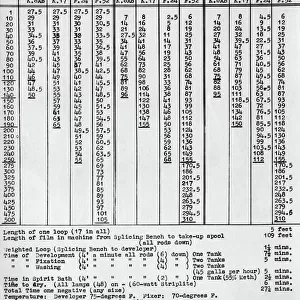
Aerial Photography for Mapping Heights

![]()
Wall Art and Photo Gifts from Mary Evans Picture Library
Aerial Photography for Mapping Heights
Aerial Photography for Mapping Heights Date: 1940s
Mary Evans Picture Library makes available wonderful images created for people to enjoy over the centuries
Media ID 18412712
© aviation-images.com / Mary Evans Picture Library
FEATURES IN THESE COLLECTIONS
> Aerial Photography
> England
> Europe
> United Kingdom
> England
> Aviation
> Mary Evans Prints Online
> Aviation Images
EDITORS COMMENTS
1. Title: Aerial Photography for Mapping Heights: Unveiling the British Isles from the Sky (1940s) This evocative black-and-white photograph captures the essence of aerial reconnaissance during the 1940s, with a Royal Air Force (RAF) plane soaring above the verdant landscapes of England. The image, taken from the collection at Mary Evans Prints Online, showcases the power and innovation of aerial photography for mapping heights, a crucial aspect of military intelligence during that era. The RAF aircraft, identified as an Avro Anson Mk.I, is seen cruising effortlessly over the English countryside. Its wings are spread wide, revealing the intricate details of the aircraft's design, while the propellers churn the air beneath, leaving a trail of white vapor in their wake. The plane's registration number, G-AGUB, can be discerned on the fuselage, adding a touch of authenticity to the scene. Beneath the plane, the quilted pattern of fields stretches out, dotted with clusters of trees and the occasional village or hamlet. The River Thames meanders through the landscape, its sinuous path easily traced from this vantage point. The image offers a unique perspective on the British Isles, revealing the intricacies of the terrain that would have been invaluable for military planning and strategic operations. The photograph was likely taken at RAF Benson, a Royal Flying Corps station established in 1916, located in Oxfordshire, England. The base was renowned for its pioneering work in aerial photography and mapping, using aircraft like the Avro Anson to survey the land from above. This photograph is a testament to the ingenuity and determination of the RAF during the 1940s, as they harnessed the power of aerial photography to gain a new perspective on the world around them.
MADE IN THE USA
Safe Shipping with 30 Day Money Back Guarantee
FREE PERSONALISATION*
We are proud to offer a range of customisation features including Personalised Captions, Color Filters and Picture Zoom Tools
FREE COLORIZATION SERVICE
You can choose advanced AI Colorization for this picture at no extra charge!
SECURE PAYMENTS
We happily accept a wide range of payment options so you can pay for the things you need in the way that is most convenient for you
* Options may vary by product and licensing agreement. Zoomed Pictures can be adjusted in the Cart.