Home > Europe > France > Military
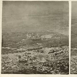
Aerial view, shelled area in Northern France, WW1

![]()
Wall Art and Photo Gifts from Mary Evans Picture Library
Aerial view, shelled area in Northern France, WW1
Oblique aerial view of a shelled area in Northern France on 21 August 1918. Date: 1918
Mary Evans Picture Library makes available wonderful images created for people to enjoy over the centuries
Media ID 14415199
© The Patricia Aubrey Collection / Mary Evans
Auerbach Corps Fields Harold Observation Reconnaissance Squadron
FEATURES IN THESE COLLECTIONS
EDITORS COMMENTS
This oblique aerial photograph, taken on August 21, 1918, captures the devastating impact of war in the rural countryside of Northern France during World War I. The scene depicts a shelled area, likely the result of intense artillery fire or bombing raids, in the northern part of the region. The Royal Flying Corps (RFC), the military aviation branch of the British Army during the war, captured this image as part of their reconnaissance and observation missions. The RFC squadrons played a crucial role in providing real-time intelligence to the military commanders on the ground, enabling them to make informed decisions about troop movements, enemy positions, and the assessment of damage caused by the enemy. This photograph is a stark reminder of the destructive power of war and the devastating effects it had on the civilian population and the natural environment. The image shows a vast expanse of land, with fields and farmlands reduced to rubble and ashes. The once lush and green countryside is now a desolate wasteland, with the remnants of trees and buildings scattered across the landscape. The destruction is evident in every direction, with the telltale signs of shell craters and smoke rising from the ground. The photograph, taken from an airplane, offers a unique perspective of the devastation, revealing the true extent of the damage inflicted during the war. The aerial view also highlights the isolation and desolation of the area, with no signs of human presence or activity in sight. This image serves as a poignant reminder of the human cost of war and the long-lasting impact it has on the land and the people who inhabit it.
MADE IN THE USA
Safe Shipping with 30 Day Money Back Guarantee
FREE PERSONALISATION*
We are proud to offer a range of customisation features including Personalised Captions, Color Filters and Picture Zoom Tools
SECURE PAYMENTS
We happily accept a wide range of payment options so you can pay for the things you need in the way that is most convenient for you
* Options may vary by product and licensing agreement. Zoomed Pictures can be adjusted in the Cart.