Home > Maps and Charts > World
Photographic Print : Maps / World / Ptolemy 2Ad


![]()
Photo Prints from Mary Evans Picture Library
Maps / World / Ptolemy 2Ad
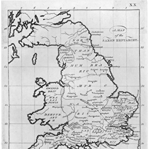
The world as seen by Ptolemy
Mary Evans Picture Library makes available wonderful images created for people to enjoy over the centuries
Media ID 581517
© Mary Evans Picture Library 2015 - https://copyrighthub.org/s0/hub1/creation/maryevans/MaryEvansPictureID/10027525
14"x11" Photo Print
Introducing the captivating "Maps / World / Ptolemy 2Ad" print from the Media Storehouse collection, brought to you by Mary Evans Picture Library via Mary Evans Prints Online. This exquisite piece transports you back in time, showcasing the world as it was once perceived by the renowned ancient Greek geographer Ptolemy. With intricate detail and vibrant colors, this print is a stunning addition to any space, whether it's an office, living room, or gallery wall. Immerse yourself in history and ignite your imagination with the timeless beauty of this Ptolemaic world map. Order your print today and bring a piece of the past into your present.
Photo prints are produced on Kodak professional photo paper resulting in timeless and breath-taking prints which are also ideal for framing. The colors produced are rich and vivid, with accurate blacks and pristine whites, resulting in prints that are truly timeless and magnificent. Whether you're looking to display your prints in your home, office, or gallery, our range of photographic prints are sure to impress. Dimensions refers to the size of the paper in inches.
Our Photo Prints are in a large range of sizes and are printed on Archival Quality Paper for excellent colour reproduction and longevity. They are ideal for framing (our Framed Prints use these) at a reasonable cost. Alternatives include cheaper Poster Prints and higher quality Fine Art Paper, the choice of which is largely dependant on your budget.
Estimated Image Size (if not cropped) is 35.5cm x 24.3cm (14" x 9.6")
Estimated Product Size is 35.5cm x 27.9cm (14" x 11")
These are individually made so all sizes are approximate
Artwork printed orientated as per the preview above, with landscape (horizontal) orientation to match the source image.
FEATURES IN THESE COLLECTIONS
> Maps and Charts
> Early Maps
> Maps and Charts
> World
> Mary Evans Prints Online
> Maps
EDITORS COMMENTS
This stunning print captures a glimpse into the ancient world as seen through the eyes of Ptolemy, a renowned Greek astronomer and geographer from the 2nd century AD. The intricate map depicted in this image showcases Ptolemy's groundbreaking work in cartography, offering a unique perspective on how people viewed the world centuries ago.
The detailed craftsmanship and historical significance of this piece make it a true treasure for history enthusiasts and scholars alike. As we study this map, we are transported back in time to an era when exploration and discovery were at the forefront of human curiosity.
Through Ptolemy's meticulous observations and calculations, he was able to create one of the most accurate maps of his time, laying the foundation for future generations of explorers and navigators. This print serves as a reminder of our shared history and the importance of understanding where we come from.
Whether displayed in a classroom, library, or personal collection, this print is sure to spark conversations about ancient civilizations, geography, and the enduring legacy of Ptolemy's contributions to our understanding of the world. It is not just a piece of art but also a window into our collective past that continues to inspire us today.
MADE IN THE USA
Safe Shipping with 30 Day Money Back Guarantee
FREE PERSONALISATION*
We are proud to offer a range of customisation features including Personalised Captions, Color Filters and Picture Zoom Tools
SECURE PAYMENTS
We happily accept a wide range of payment options so you can pay for the things you need in the way that is most convenient for you
* Options may vary by product and licensing agreement. Zoomed Pictures can be adjusted in the Cart.